San Martin de Porres District
| San Martín de Porres | ||
|---|---|---|
| District | ||

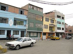
A street in San Martin de Porres
|
||
|
||
|
Location of San Martín de Porres in Lima |
||
| Country |
|
|
| Region | Lima | |
| Province | Lima | |
| Founded | May 22, 1950 | |
| Capital | Barrion Obrero Industrial | |
| Subdivisions | 1 populated center | |
| Government | ||
| • Mayor | Freddy Santos Ternero Corrales | |
| Area | ||
| • Total | 36.91 km2 (14.25 sq mi) | |
| Elevation | 123 m (404 ft) | |
| Population (2005 census) | ||
| • Total | 525,155 | |
| • Density | 14,000/km2 (37,000/sq mi) | |
| Time zone | PET (UTC-5) | |
| UBIGEO | 150135 | |
| Website | mdsmp.gob.pe | |
San Martín de Porres (SMP) is a district in Lima, Peru, located in the area known as Cono Norte. It is bordered by the district of Callao on the west; Los Olivos on the northeast; and the Rímac and Independencia districts on the east. The Rímac River marks its natural border with downtown Lima and Callao province's district of Carmen de la Legua Reynoso on the south; while the Chillón River, on the north, marks San Martín de Porres' border with Ventanilla, also in Callao, and Puente Piedra.
Since 1945, continuous invasions of territory in what was then part of the Carabayllo District ended up in the creation of the Distrito Obrero Industrial 27 de Octubre on May 22, 1950, which is still celebrated as the district's anniversary. The district was composed of the following haciendas: Chuquitanta, Pro, Naranjal, Infantas, Santa Rosa, Garagay Alto, G. Bajo, Chavarría, Mulería, Aliaga, Condevilla, San José, Palao, and the Huerta Sol.
In 1962, after the canonization of St. Martin de Porras, the name of the district was changed to its current name. Although historians have shown that the saint's actual last name was Porras, the district has retained the original spelling. The Barrio Obrero Industrial name is unofficially kept for the downtown area (south of Ave. José Granda).
The district of Los Olivos was created in 1989, stripping some of San Martín de Porres' northeastern territory.
A prominent geographical feature of the district is the isolated La Milla hill, which is north of Ave. José Granda.
...
Wikipedia

