Satevó
| Satevó | |
|---|---|
| Municipality | |
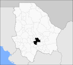
 Municipality of Satevó in Chihuahua |
|
| Location in Mexico | |
| Coordinates: 27°57′15″N 106°6′23″W / 27.95417°N 106.10639°WCoordinates: 27°57′15″N 106°6′23″W / 27.95417°N 106.10639°W | |
| Country |
|
| State | Chihuahua |
| Municipal seat | San Francisco Javier de Satevó |
| Area | |
| • Total | 2,185.1 km2 (843.7 sq mi) |
| Elevation | 1,380 m (4,530 ft) |
| Population (2010) | |
| • Total | 3,662 |
| • Density | 1.7/km2 (4.3/sq mi) |
| Website | www.satevo.gob.mx |
Satevó is one of the 67 municipalities of Chihuahua, in northern Mexico. The municipal seat lies at San Francisco Javier de Satevó. The municipality covers an area of 2,185.1 km².
As of 2010, the municipality had a total population of 3,662, down from 3,856 as of 2005.
The municipality had 244 localities, none of which had a population over 1,000.
Satevó began as a Jesuit mission to the Tarahumara in about 1640.
The municipality has 126 localities. The largest are:
...
Wikipedia

