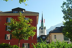
Schwanden, Glarus
| Schwanden | ||
|---|---|---|
| Village (and former municipality) | ||
 |
||
|
||
 The former municipal area (2007) |
||
| Coordinates: 46°59′39″N 9°4′30″E / 46.99417°N 9.07500°ECoordinates: 46°59′39″N 9°4′30″E / 46.99417°N 9.07500°E | ||
| Country | Switzerland | |
| Canton | Glarus | |
| Municipality | Glarus Süd | |
| Area | ||
| • Total | 30.63 km2 (11.83 sq mi) | |
| Elevation | 528 m (1,732 ft) | |
| Population (December 2010) | ||
| • Total | 2,392 | |
| • Density | 78/km2 (200/sq mi) | |
Schwanden is a village, and former municipality, in the municipality of Glarus Süd and canton of Glarus in Switzerland.
Schwanden is first mentioned in 1240 as de swando.
In 1879, Schwanden was connected to the Swiss railway network by the opening of the Swiss Northeastern Railway line from Weesen. Between 1905 and 1969, the Sernftal tramway connected Schwanden with communities in the valley of the Sernf river as far as Elm.
On 1 January 2011, Schwanden became part of the municipality of Glarus Süd.
Schwanden is situated at an elevation of 528 m (1,732 ft) at the point of confluence of the Linth and Sernf rivers. The village is located along the roads to Elm, Linthal and Schwändi, and includes the formerly independent (until 1876) hamlet of Thon. The villages of Nidfurn and Haslen lie to south in the valley of the Linth, whilst the village of Engi lies to the east in the valley of the Sernf. To the north, the village of Mitlödi lies in the valley of the Linth, whilst Schwandi and Sool are respectively on the west and east slopes of the valley.
South of Schwanden is the oldest Jagdbanngebiet (literally hunting-banned area) in Switzerland, the Freiberg Kärpf, which has been protected since 1548. Also to the south, the Niederenbäch stream descends from the slopes of the mountain of Kärpf (2,794 m or 9,167 ft). This stream has been dammed to create the Garichtisee reservoir.
...
Wikipedia

