Searsmont, Maine
| Searsmont, Maine | |
|---|---|
| Town | |

General view in 1908
|
|
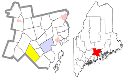
 Location of Searsmont (in yellow) in Waldo County and the state of Maine |
|
| Coordinates: 44°22′10″N 69°11′18″W / 44.36944°N 69.18833°W | |
| Country | United States |
| State | Maine |
| County | Waldo |
| Incorporated | 1814 |
| Area | |
| • Total | 39.15 sq mi (101.40 km2) |
| • Land | 37.74 sq mi (97.75 km2) |
| • Water | 1.41 sq mi (3.65 km2) |
| Elevation | 207 ft (63 m) |
| Population (2010) | |
| • Total | 1,392 |
| • Estimate (2012) | 1,399 |
| • Density | 36.9/sq mi (14.2/km2) |
| Time zone | Eastern (EST) (UTC-5) |
| • Summer (DST) | EDT (UTC-4) |
| ZIP code | 04973 |
| Area code(s) | 207 |
| FIPS code | 23-66565 |
| GNIS feature ID | 0582715 |
| Website | Town of Searsmont |
Searsmont is a town in Waldo County, Maine, United States. The population was 1,392 at the 2010 census.
Located at the junction of several well-marked Indian trails, it was called Quantabacook. The town was a part of the Waldo Patent purchased by a consortium of wealthy Boston investors which included David Sears. First settled in 1804 and called Fraternity Village by Ben Ames Williams, it was incorporated on February 5, 1814 as Searsmont, named after its proprietor.
The town was noted for its productive soil, water power and abundant forests of white pine. By 1859, when the population was 1,693, it had fifteen sawmills and two gristmills. In 1886, it had five lumber mills, three cooperages, a sash, blind and pump factory, four carriage factories, a tannery, a boot and shoe factory, and a coffin and bedstead factory.
Today, Searsmont continues its lumbering heritage with one mill in town.
According to the United States Census Bureau, the town has a total area of 39.15 square miles (101.40 km2), of which, 37.74 square miles (97.75 km2) of it is land and 1.41 square miles (3.65 km2) is water. Adjacent to Quantabacook Lake (665 acres), Searsmont is drained by the St. George River. Other ponds include Levenseller Pond (34 acres), Lawry Pond (85 acres), Ruffingham Meadow (51 acres) and Little Pond (42 acres).
...
Wikipedia
