Shaker Heights, OH
| Shaker Heights | ||
|---|---|---|
| City | ||
 |
||
|
||
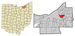
 Location in Cuyahoga County and the state of Ohio. |
||
 Location of Ohio in the United States |
||
| Coordinates: 41°28′35″N 81°33′6″W / 41.47639°N 81.55167°W | ||
| Country | United States | |
| State | Ohio | |
| County | Cuyahoga | |
| Established | 1911 | |
| Incorporated | 1912 | |
| Government | ||
| • Mayor | Earl Leiken (D) | |
| Area | ||
| • Total | 6.32 sq mi (16.37 km2) | |
| • Land | 6.28 sq mi (16.27 km2) | |
| • Water | 0.04 sq mi (0.10 km2) | |
| Elevation | 1,050 ft (320 m) | |
| Population (2010) | ||
| • Total | 28,448 | |
| • Estimate (2012) | 28,039 | |
| • Density | 4,529.9/sq mi (1,749.0/km2) | |
| Time zone | Eastern (EST) (UTC-5) | |
| • Summer (DST) | EDT (UTC-4) | |
| ZIP codes | 44118, 44120, 44122 | |
| Area code(s) | 216 | |
| FIPS code | 39-71682 | |
| GNIS feature ID | 1065308 | |
| Website | www.shakeronline.com | |
Shaker Heights is a city in Cuyahoga County, Ohio, United States. As of the 2010 Census, the city population was 28,448. Shaker Heights is an inner-ring streetcar suburb of Cleveland, abutting the eastern edge of the city's limits. In July 1911, a petition by property owners was successful in detaching a long strip of land from the south of Cleveland Heights, to be named Shaker Village. In November 1911, the voters of Shaker Village formed Shaker Heights Village, which was incorporated in January 1912.
Shaker Heights was a planned community developed by the Van Sweringen brothers, railroad moguls who envisioned the community as a suburban retreat from the industrial inner city of Cleveland.
Shaker Heights is located at 41°28′35″N 81°33′6″W / 41.47639°N 81.55167°WCoordinates: 41°28′35″N 81°33′6″W / 41.47639°N 81.55167°W. According to the United States Census Bureau, the city has a total area of 6.32 square miles (16.37 km2), of which 6.28 square miles (16.27 km2) is land and 0.04 square miles (0.10 km2) is water.
...
Wikipedia
