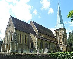
Shalford, Surrey
| Shalford | |
|---|---|
 St Mary the Virgin's Church, Shalford |
|
| Shalford shown within Surrey | |
| Area | 6.51 km2 (2.51 sq mi) |
| Population | 4,142 (Civil Parish 2011) |
| • Density | 636/km2 (1,650/sq mi) |
| OS grid reference | TQ0046 |
| Civil parish |
|
| District | |
| Shire county | |
| Region | |
| Country | England |
| Sovereign state | United Kingdom |
| Post town | Guildford |
| Postcode district | GU4 |
| Dialling code | 01483 |
| Police | Surrey |
| Fire | Surrey |
| Ambulance | South East Coast |
| EU Parliament | South East England |
| UK Parliament | |
Shalford is a village and civil parish in Surrey, England on the A281 Horsham road immediately south of Guildford. It has a railway station which is between Guildford and Dorking on the Reading to Gatwick Airport line.
It has one named locality, occupying the west of the area, Peasmarsh.
Shalford appears in Domesday Book of 1086 as Scaldefor. It was held by Robert de Wateville from Richard Fitz Gilbert. Its domesday assets were: 4 hides; 1 church, 3 mills worth 16s, 11½ ploughs, 4 acres (1.6 ha) of meadow, wood worth 20 hogs. It rendered £20.
The village also became well known for "the Great Fair of Shalford" which was set up by a charter issued by King John. In its heyday, it was said to have covered 140 acres (570,000 m²) and attracted merchants from across the country.
The mills continued to be built and operated there for hundreds of years. One still survives intact today.
The original church, mentioned in the Domesday survey, no longer exists. An early Victorian church now stands in its place. St Mary's was built in 1846 with a lychgate and stained glass. Many older cottages do survive. One of the finest properties, Shalford House, dated back to the Tudor period and featured a carved stone fireplace dated 1609. Unfortunately, Shalford House was demolished in 1967 to make way for a water treatment plant. There are many Grade II listed structures including .
The River Tillingbourne joins the River Wey at Shalford adjacent to the parish church. For centuries, the river provided an important source of income for the village demonstrated by the industries mentioned by those articles, such as gunpowder manufacture. Cranleigh Waters joins the Wey at the northern terminus of the Wey and Arun Canal/East Branch of the Wey. Shalford was a landing place for barges, and continues to be visited by boats today – but for pleasure rather than trade.
...
Wikipedia

