Singsås
| Singsås herad | |
|---|---|
| Former Municipality | |

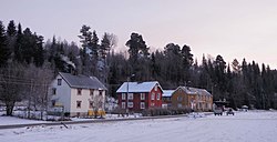
View of the village from Singsås Station
|
|
| Municipality ID | NO-1646 |
| Adm. Center | Singsås |
| Area | |
| • Total | 767 km2 (296 sq mi) |
| Created from | Holtålen in 1841 |
| Merged into | Midtre Gauldal in 1964 |
| Singsås | |
|---|---|
| Village | |
| Location in Sør-Trøndelag | |
| Coordinates: 62°57′22″N 10°43′50″E / 62.95611°N 10.73056°ECoordinates: 62°57′22″N 10°43′50″E / 62.95611°N 10.73056°E | |
| Country | Norway |
| Region | Trøndelag |
| County | Sør-Trøndelag |
| District | Gauldalen |
| Municipality | Midtre Gauldal |
| Elevation | 182 m (597 ft) |
| Time zone | CET (UTC+01:00) |
| • Summer (DST) | CEST (UTC+02:00) |
| Post Code | 7387 Singsås |
Singsås is a village and former municipality in Sør-Trøndelag county, Norway. It encompassed the eastern part of the present-day municipality of Midtre Gauldal. The administrative center was the village of Singsås, where the Singsås Church is also located. The village of Singsås is located along the Gaula River, the Rørosbanen railway, and the highway Fylkesvei 30.
The municipality of Singsås (originally spelled Singsaas) was established in 1841 when it was separated from Holtålen (see formannskapsdistrikt). Initially, Singsås had a population of 1,272. On 1 January 1964, Singsås was merged with the municipalities of Budal, Soknedal, and Støren to form the new municipality of Midtre Gauldal. Before the merger, Singsås had a population of 1,554.
...
Wikipedia


