Sint-Amands
| Sint-Amands | |||
|---|---|---|---|
| Municipality | |||

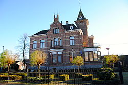
Sint-Amands town hall
|
|||
|
|||
| Location in Belgium | |||
| Coordinates: 51°03′N 04°12′E / 51.050°N 4.200°ECoordinates: 51°03′N 04°12′E / 51.050°N 4.200°E | |||
| Country | Belgium | ||
| Community | Flemish Community | ||
| Region | Flemish Region | ||
| Province | Antwerp | ||
| Arrondissement | Mechelen | ||
| Government | |||
| • Mayor | Peter Van Hoeymissen (CD&V) | ||
| • Governing party/ies | CD&V | ||
| Area | |||
| • Total | 15.58 km2 (6.02 sq mi) | ||
| Population (1 January 2016) | |||
| • Total | 8,332 | ||
| • Density | 530/km2 (1,400/sq mi) | ||
| Postal codes | 2890 | ||
| Area codes | 052, 03 | ||
| Website | www.sint-amands.be | ||
Sint-Amands (Dutch pronunciation: [ˌsɪnt ɑˈmɑnts]) is a municipality located in the Belgian province of Antwerp, Belgium. The municipality comprises the towns of Lippelo, Oppuurs and Sint-Amands proper. On January 1, 2006 Sint-Amands had a total population of 7,781. The total area is 15.58 km² which gives a population density of 500 inhabitants per km². Sint-Amands is located at the right bank of the Scheldt river.
...
Wikipedia


