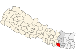
Siraha District
| Siraha सिराहा जिल्ला |
|
|---|---|
| District | |
 |
|
| Country | Nepal |
| Region | Eastern Development Region (Purba Anchal) |
| Zone | Sagarmatha |
| Headquarters | Siraha |
| Area | |
| • Total | 1,188 km2 (459 sq mi) |
| Population (2011) | |
| • Total | 637,328 |
| • Density | 540/km2 (1,400/sq mi) |
| Time zone | NPT (UTC+5:45) |
| Website | http://ddcsiraha.gov.np |
Siraha District (Nepali: ![]() Listen , a part of Province No. 2, is one of the seventy-five districts of Nepal. The district, with Siraha as its district headquarters, covers an area of 1,188 km². It has population of 637,328 in 2011.
Listen , a part of Province No. 2, is one of the seventy-five districts of Nepal. The district, with Siraha as its district headquarters, covers an area of 1,188 km². It has population of 637,328 in 2011.
Coordinates: 26°39′0″N 86°12′0″E / 26.65000°N 86.20000°E
...
Wikipedia
