Skirrid
| Ysgyryd Fawr | |
|---|---|

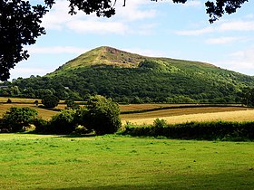
Ysgyryd Fawr from the north
|
|
| Highest point | |
| Elevation | 486 m (1,594 ft) |
| Prominence | 344 m (1,129 ft) |
| Parent peak | Sugar Loaf |
| Listing | Marilyn |
| Naming | |
| Translation | Great shattered [hill] (Welsh) |
| Pronunciation | Welsh: [ɐsˈɡɐɾɪd ˈvæuɾ] |
| Geography | |
| Location | Monmouthshire, Wales |
| Parent range | Black Mountains |
| OS grid | SO331182 |
| Topo map | OS Landranger 161 |
Ysgyryd Fawr (English: Skirrid Fawr) is an easterly outlier of the Black Mountains in Wales, and forms the easternmost part of the Brecon Beacons National Park. The mountain is often referred to locally as just The Skirrid. The smaller hill of Ysgyryd Fach or 'Little Skirrid' (270m) lies about 4.5 km / 2.5 mi to the south.
It is 486 m or 1594 feet high and lies just to the north-east of Abergavenny, Monmouthshire, about 10 miles from the English border. The Beacons Way passes along the ridge.
The distinctive shape of this Old Red Sandstone hill comprises a long ridge oriented nearly north–south, with a jagged western side resulting from ice age landslips . The upper slopes of the hill are composed of Devonian age sandstones assigned to the Senni Formation (formerly known as the 'Senni Beds'). These overlie weaker mudstones of the St Maughans Formation - a situation which has contributed to the instability of the hill's steep flanks, resulting in a very large landslip at the northern end of the mountain, although the British Geological Survey map of the area (Abergavenny sheet) shows the landslide extending along the whole of the west side of the mountain. There are numerous other landslips of a similar nature on the nearby hills, although that on the Skirrid is perhaps the most well known owing to its visibility from several directions. There are also numerous rock tables on the hill, some of which were formed by the landslide, and have attracted names such as the "Devil's table". The ridge is very similar in its rocky edge to that found on the Black Hill to the north in Herefordshire.
...
Wikipedia
