Slabinja
| Slabinja | |
|---|---|
| Village | |

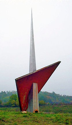
Monument to fallen fighters and victims of fascism from Slabinja
|
|
| Location of Slabinja within Croatia | |
| Coordinates: 45°12′17″N 16°41′55″E / 45.20472°N 16.69861°ECoordinates: 45°12′17″N 16°41′55″E / 45.20472°N 16.69861°E | |
| Country |
|
| Region | Banija |
| County |
|
| Municipality | Hrvatska Dubica |
| Area | |
| • Total | 17.89 km2 (6.91 sq mi) |
| Elevation | 113 m (371 ft) |
| Population (2011) | |
| • Total | 348 |
| • Density | 19/km2 (50/sq mi) |
| Time zone | CET (UTC+1) |
| • Summer (DST) | CEST (UTC+2) |
| Area code(s) | 044 |
Slabinja (Serbian Cyrillic: Слабиња) is a village in central Croatia in the Sisak-Moslavina County. According to the 2011 census, the village had 348 inhabitants in 119 family households. It is located in the Banija region, near the border with Bosnia and Herzegovina.
Slabinja is situated in the valley of the river Una, in the Petrinja-Dubica Downs microregion in central Croatia, 9 kilometers northwest of Hrvatska Dubica. It is connected by the D47 highway.
The main economic activities are agriculture and livestock.
In the Serbian Orthodox Church administrative division Slabinja belongs to Kostajnica-Dvor Parsonage at Eparchy of upper Karlovac. In the Roman Catholic Church administration belongs to the Holy Trinity Parish from Dubica, Dubica-Kostajnica Deanery of Diocese of Sisak
On the south side of the D47 road, towards the river Una, are the ruins of the Church of Saint Parascheva. The Church was built in 1828. In 1944, during World War II, it's mined by the Ustasha damaging roof structure, vault, interior and church inventory. After World War II ruins remained standing. In 1970 began the reconstruction of this valuable buildings, but roof, unfortunately, was never set up. The Church is located in the center of village.
...
Wikipedia

