Somerdale, New Jersey
| Somerdale, New Jersey | |
|---|---|
| Borough | |
| Borough of Somerdale | |
 Somerdale highlighted in Camden County. Inset: Location of Camden County in New Jersey. |
|
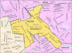
 Census Bureau map of Somerdale, New Jersey |
|
| Coordinates: 39°50′43″N 75°01′18″W / 39.845391°N 75.021701°WCoordinates: 39°50′43″N 75°01′18″W / 39.845391°N 75.021701°W | |
| Country |
|
| State |
|
| County | Camden |
| Incorporated | April 23, 1929 |
| Government | |
| • Type | Borough |
| • Body | Borough Council |
| • Mayor | Gary J. Passanante (D, term ends December 31, 2019) |
| • Administrator | Victor Cantillo |
| • Clerk | Michele Miller |
| Area | |
| • Total | 1.387 sq mi (3.592 km2) |
| • Land | 1.387 sq mi (3.592 km2) |
| • Water | 0.000 sq mi (0.000 km2) 0.00% |
| Area rank | 462nd of 566 in state 26th of 37 in county |
| Elevation | 85 ft (26 m) |
| Population (2010 Census) | |
| • Total | 5,151 |
| • Estimate (2015) | 5,460 |
| • Rank | 372nd of 566 in state 22nd of 37 in county |
| • Density | 3,714.0/sq mi (1,434.0/km2) |
| • Density rank | 169th of 566 in state 22nd of 37 in county |
| Time zone | Eastern (EST) (UTC-5) |
| • Summer (DST) | Eastern (EDT) (UTC-4) |
| ZIP code | 08083 |
| Area code(s) | 856 |
| FIPS code | 3400768340 |
| GNIS feature ID | 0885396 |
| Website | www |
Somerdale is a borough in Camden County, New Jersey, United States. As of the 2010 United States Census, the borough's population was 5,151, reflecting a decline of 41 (-0.8%) from the 5,192 counted in the 2000 Census, which had in turn declined by 248 (-4.6%) from the 5,440 counted in the 1990 Census.
The Borough of Somerdale was created on April 23, 1929, from Clementon Township, one of seven municipalities created from the now-defunct township, and one of five new municipalities (including Hi-Nella Borough, Lindenwold Borough, Pine Hill Borough and Pine Valley Borough) created on that same date.
According to the United States Census Bureau, the borough had a total area of 1.387 square miles (3.592 km2), all of which was land.
Somerdale borders the Camden County municipalities of Cherry Hill, Gloucester Township, Hi-Nella, Lawnside, Lindenwold, Magnolia, Stratford, Voorhees Township.
The 2010 United States Census counted 5,151 people, 2,026 households, and 1,345 families residing in the borough. The population density was 3,714.0 per square mile (1,434.0/km2). The borough contained 2,158 housing units at an average density of 1,556.0 per square mile (600.8/km2). The racial makeup of the borough was 68.20% (3,513) White, 18.99% (978) Black or African American, 0.08% (4) Native American, 6.00% (309) Asian, 0.02% (1) Pacific Islander, 3.07% (158) from other races, and 3.65% (188) from two or more races. Hispanics or Latinos of any race were 8.19% (422) of the population.
...
Wikipedia
