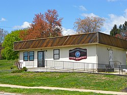
South Coatesville, Pennsylvania
| Borough of South Coatesville | |
| Borough | |
|
Police headquarters
|
|
| Country | United States |
|---|---|
| State | Pennsylvania |
| County | Chester |
| Elevation | 397 ft (121.0 m) |
| Coordinates | 39°58′17″N 75°48′43″W / 39.97139°N 75.81194°WCoordinates: 39°58′17″N 75°48′43″W / 39.97139°N 75.81194°W |
| Area | 1.7 sq mi (4.4 km2) |
| - land | 1.7 sq mi (4 km2) |
| - water | 0.0 sq mi (0 km2), 0% |
| Population | 1,303 (2010) |
| Density | 766.5/sq mi (295.9/km2) |
| Timezone | EST (UTC-5) |
| - summer (DST) | EDT (UTC-4) |
| ZIP code | 19320 |
| Area code | 610 and 484 |
|
Location in Chester County and the state of Pennsylvania.
|
|
|
Location of Pennsylvania in the United States
|
|
South Coatesville is a borough in Chester County, Pennsylvania, United States. The population was 1,303 at the 2010 census.
South Coatesville is located at 39°58′17″N 75°48′43″W / 39.97139°N 75.81194°W (39.971306, -75.812023).
According to the United States Census Bureau, the borough has a total area of 1.7 square miles (4.4 km2), all of it land.
At the 2010 census, the borough was 35.3% non-Hispanic White, 47.9% Black or African American, 0.2% Native American, 0.3% Asian, and 5.2% were two or more races. 13.0% of the population were of Hispanic or Latino ancestry [1].
As of the census of 2000, there were 997 people, 376 households, and 263 families residing in the borough. The population density was 586.2 people per square mile (226.4/km²). There were 419 housing units at an average density of 246.3 per square mile (95.2/km²). The racial makeup of the borough was 34.80% White, 56.07% African American, 0.20% Native American, 0.30% Pacific Islander, 4.11% from other races, and 4.51% from two or more races. Hispanic or Latino of any race were 8.93% of the population.
...
Wikipedia


