South Sulawesi Province
|
South Sulawesi Sulawesi Selatan |
|||
|---|---|---|---|
| Province | |||
| Other transcription(s) | |||
| • Buginese | ᨔᨘᨒᨕᨙᨔᨗ ᨒᨕᨘᨈ | ||
|
Clockwise, from top left : Makassar Skyline Night, Bili-bili Reservoir, Tongkonan houses in Tana Toraja, Limestone hills in Maros, Rice fields in South Sulawesi, Floating houses on Lake Tempe, Tanjung Bira beach
|
|||
|
|||
| Motto(s): Toddo' Puli / ᨈᨚᨉᨚᨄᨘᨒᨗ (Keep the faith) |
|||
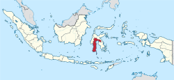
 Location of South Sulawesi in Indonesia |
|||
| Coordinates: 4°20′S 120°15′E / 4.333°S 120.250°ECoordinates: 4°20′S 120°15′E / 4.333°S 120.250°E | |||
| Country |
|
||
| Founded | 19 October 1669 | ||
| Founded As Province | 13 December 1960 | ||
| Capital |
|
||
| Government | |||
| • Body | South Sulawesi Regional Government | ||
| • Governor | Syahrul Yasin Limpo (Golkar) | ||
| • Vice Governor | Agus Arifin Nu'mang | ||
| Area | |||
| • Total | 46,717.48 km2 (18,037.72 sq mi) | ||
| Area rank | 16th | ||
| Highest elevation | 3,478 m (11,411 ft) | ||
| Population (2010) | |||
| • Total | 8,032,551 | ||
| • Density | 170/km2 (450/sq mi) | ||
| Demographics | |||
| • Ethnic groups | Bugis (41.9%), Makassarese (25.43%), Toraja (9.02%), Mandar (6.1%) | ||
| • Religion | Islam (89.62%), Protestantism (7.62%), Roman Catholicism (1.54%), Buddhism (0.24%), Hinduism (0.72%), Confucianism (0.004) | ||
| • Languages |
Indonesian (official) Buginese (regional) Makassarese (regional) Torajanese (regional) Mandar (regional) |
||
| Time zone | Indonesia Central Time (UTC+08) | ||
| Postcodes | 90xxx, 91xxx, 92xxx | ||
| Area codes | (+62) 4xx | ||
| ISO 3166 code | ID-SN | ||
| Vehicle sign | DD, DP, DW | ||
| HDI |
|
||
| HDI rank | 14th (2014) | ||
| Largest city by area | Palopo - 247.52 square kilometres (95.57 sq mi) | ||
| Largest city by population | Makassar - (1,339,374 - 2010) | ||
| Largest regency by area | North Luwu Regency - 7,502.58 square kilometres (2,896.76 sq mi) | ||
| Largest regency by population | Bone Regency - (717,268 - 2010) | ||
| Website | Government official site | ||
South Sulawesi (Indonesian: Sulawesi Selatan; Buginese: ᨔᨘᨒᨓᨙᨔᨗ ᨒᨕᨘᨈ ) is a province in the southern peninsula of Sulawesi. The Selayar Islands archipelago is also part of the province. The capital is Makassar. The province is bordered by Central Sulawesi and West Sulawesi to the north, the Gulf of Bone and Southeast Sulawesi to the east, Makassar Strait to the west, and Flores Sea to the south.
The 2010 census estimated the population as 8,032,551 which makes South Sulawesi the most populous province on the island (46% of the population of Sulawesi is in South Sulawesi), and the sixth most populous province in Indonesia. The main ethnic groups in South Sulawesi are the Buginese, Makassarese, Toraja, and Mandar. The economy of the province is based on agriculture,, fishing, and mining of gold, magnesium, iron and other metals. The pinisi, a traditional Indonesian two-masted sailing ship, is still used widely by the Buginese and Makassarese, mostly for inter-insular transportation, cargo, and fishing purposes within the Indonesian archipelago.
During the golden era of the spice trade, from the 15th to 19th centuries, South Sulawesi served as the gateway to the Maluku Islands. There were a number of small kingdoms, including two prominent ones, the Kingdom of Gowa near Makassar and the Bugis kingdom located in Bone. The Dutch East India Company (VOC) began operating in the region in the 15th century. VOC later allied with the Bugis prince, Arung Palakka, and they defeated the kingdom of Gowa. The king of Gowa, Sultan Hasanuddin was forced to sign a treaty which greatly reduced the power of Bungaya Gowa.
...
Wikipedia


