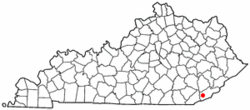
South Wallins, Kentucky
| South Wallins, Kentucky | |
|---|---|
| Census-designated place | |
 Location of South Wallins, Kentucky |
|
| Coordinates: 36°48′59″N 83°24′41″W / 36.81639°N 83.41139°WCoordinates: 36°48′59″N 83°24′41″W / 36.81639°N 83.41139°W | |
| Country | United States |
| State | Kentucky |
| County | Harlan |
| Area | |
| • Total | 6.34 sq mi (16.43 km2) |
| • Land | 6.31 sq mi (16.35 km2) |
| • Water | 0.03 sq mi (0.08 km2) |
| Elevation | 1,142 ft (348 m) |
| Population (2010) | |
| • Total | 859 |
| • Density | 136/sq mi (52.6/km2) |
| Time zone | Eastern (EST) (UTC-5) |
| • Summer (DST) | EDT (UTC-4) |
| FIPS code | 21-72255 |
| GNIS feature ID | 0503985 |
South Wallins is an unincorporated community and census-designated place (CDP) in Harlan County, Kentucky, United States. The population was 859 at the 2010 census, down from 996 at the 2000 census.
South Wallins is located in western Harlan County at 36°48′59″N 83°24′41″W / 36.81639°N 83.41139°W (36.816469, -83.411475), in the valley of Wallins Creek, a north-flowing tributary of the Cumberland River. The CDP is bordered to the north by the community of Wallins Creek. Kentucky Route 219 is the main road through the community, leading north (downstream) 1.5 miles (2.4 km) to U.S. Route 119 at Wallins Creek and south 3.5 miles (5.6 km) to its dead-end in Creech.
According to the United States Census Bureau, the South Wallins CDP has a total area of 6.3 square miles (16.4 km2), of which 0.03 square miles (0.08 km2), or 0.49%, are water.
As of the census of 2000, there were 996 people, 405 households, and 287 families residing in the CDP. The population density was 158.4 people per square mile (61.1/km²). There were 448 housing units at an average density of 71.2/sq mi (27.5/km²). The racial makeup of the CDP was 97.29% White, 0.20% Native American, and 2.51% from two or more races. Hispanic or Latino of any race were 1.20% of the population.
...
Wikipedia
