Southern District (Botswana)
|
Southern Ngwaketse |
|
|---|---|
| District | |
 |
|
 Location within Botswana |
|
| Coordinates: 25°00′S 25°00′E / 25.000°S 25.000°ECoordinates: 25°00′S 25°00′E / 25.000°S 25.000°E | |
| Country |
|
| Capital | Kanye |
| Area | |
| • Total | 28,470 km2 (10,990 sq mi) |
| Population (2001 census) | |
| • Total | 186,831 |
| • Density | 6.6/km2 (17/sq mi) |
| Time zone | Central Africa Time (UTC+2) |
Southern is one of the districts of Botswana. The capital of Southern district (Ngwaketse district) is Kanye, home to the Bangwaketse, one of the largest growing villages in Botswana. The Southern district (Ngwaketse district), is home to Botswana’s second largest beef farmers where there are large privately owned ranges, and several government run beef ranges which provide agricultural support to the local farmers. Maize and sorghum, Botswana’s staple crop, are also raised in the area. Southern district is where the third diamond mine of Botswana was found (the Jwaneng diamond mine), which buoys Botswana’s economic state of prosperity. It was the first district to house the capital city before being moved to Gaborone after independence.
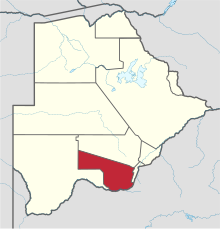
In the south, Southern borders the North West Province of South Africa. Domestically, it borders South-East District in east, Kweneng District in north, Kgalagadi District and south west.
As of 2011, the total population of the district was 197,767 compared to 171,652 in 2001. The growth rate of population during the decade was 1.43. The total number of workers constituted 51,187 with 29,043 males and 22,141 females, with a majority involved in agriculture. The district is administered by a district administration and district council which are responsible for local administration.
In the south, Southern borders the North West Province of South Africa. Domestically, it borders South-East District in east, Kweneng District in north, Kgalagadi District and south west. Southern District is traversed by the northwesterly line of equal latitude and longitude. Most part of Botswana has tableland slopes sliding from east to west. The region has an average elevation of around 915 m (3,002 ft) above the mean sea level. The vegetation type is Savannah, with tall grasses, bushes and tress. The annual precipitation is around 65 cm (26 in), most of which is received during the summer season from November to May. Most of the rivers in the region are seasonal prone to flash floods. Southern district is where the third diamond mine of Botswana was found (the Jwaneng diamond mine), which drives Botswana’s economic state of prosperity.
...
Wikipedia
