Spit Bridge
| The Spit Bridge | |
|---|---|

|
|
| Coordinates | 33°48′09″S 151°14′46″E / 33.8025°S 151.2462°ECoordinates: 33°48′09″S 151°14′46″E / 33.8025°S 151.2462°E |
| Carries | The Spit Road (A8); (Road traffic, pedestrians, bicycles) |
| Crosses | Middle Harbour |
| Locale | The Spit, Sydney, New South Wales, Australia |
| Owner | Roads & Maritime Services |
| Heritage status |
Roads & Maritime Services heritage and conservation register |
| Preceded by | The Spit Bridge (1924–1958) |
| Characteristics | |
| Design | Girder bridge with a bascule lift span |
| Material | Steel and concrete |
| Total length | 745 feet 6 inches (227.23 m) |
| Width | 54 feet (16 m) |
| No. of spans | 7 |
| History | |
| Designer | NSW Department of Main Roads |
| Constructed by | Cleveland Bridge and Engineering Company |
| Construction begin | 1952 |
| Construction end | 1958 |
| Opened | 19 November 1958 |
| Statistics | |
| Daily traffic | ~33,000 (2012) |
| References | |
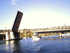
The Spit Bridge, a steel and concrete girder bridge with a bascule lift span across the Middle Harbour, is located 10 kilometres (6.2 mi) northeast of the central business district in Sydney, New South Wales, Australia. The bridge carries The Spit Road (A8) from a point called The Spit, and connects the suburbs of Mosman, on the south bank and Seaforth, on the north bank.
The Spit Bridge, completed in 1958, is of state significance. It is a substantial landscape feature that has played a crucial role in allowing the development of the northern beaches suburbs to occur over the last 44 years. The Bridge is also extremely rare as it is the only lift bridge still operational on a major arterial road. As such, the Spit Bridge is representative of all the major lift bridges that were once a common sight throughout NSW. The relative lack of modification to the original design of the Bridge also contributes to its level of significance. Historically the Bridge has a high level of significance developed primarily through being part of an important local transport route that has been in operation over a large period of time in several different guises. The Spit Bridge Cultural Landscape also contains the remnant features and locales of the former bridge and punt crossing and the remains of other transportation links such as the tramways. These additional items add to the significance of the Bridge through their ability to add to contextualise the current bridge as a single element of the crossing points colourful history.
Sydney's Lower North Shore and Northern Beaches were serviced by a punt operating from The Spit since the late nineteenth century up until 1924.
In 1924, The (first) Spit Bridge was completed and opened. By 1927 the timber low–level bridge saw a 60% growth over that of the punt for the year prior to the bridge opening. The amount of traffic using the bridge was higher than expected and the subsequent revenue from tolls providing a financial boon for the government. Various plans were considered to reduce congestion including a high-level bridge and a bridge further upstream, leaving the existing bridge for local traffic; however none were enacted until after World War II. The NSW Government decided to build another low–level bridge at the same site.
...
Wikipedia
