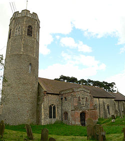
St Andrew, Ilketshall
| St Andrew, Ilketshall | |
|---|---|
 St Andrew's Church |
|
| St Andrew, Ilketshall shown within Suffolk | |
| Population | 291 (2011 Census) |
| Civil parish |
|
| District | |
| Shire county | |
| Region | |
| Country | England |
| Sovereign state | United Kingdom |
| Post town | Beccles |
| Postcode district | NR34 8 |
| Police | Suffolk |
| Fire | Suffolk |
| Ambulance | East of England |
| EU Parliament | East of England |
| UK Parliament | |
St Andrew, Ilketshall is a civil parish in the Waveney district of Suffolk, England. The population of St Andrew, Ilketshall was 291 according to the 2011 Census, of which 146 are males, and 145 are females. St Andrew's church is one of 38 existing round-tower churches in Suffolk.
St Andrew, Ilketshall is one of the several parishes in the 'Saints' area of Bungay in the district of Waveney. The district comprises the parishes of St Andrew, St John, St Laurence, St Margaret, and 'All Saints Mettingham' which includes the parishes of St Mary and Holy Trinity in Bungay. These parishes make up what is known as 'the Seven Parishes'.
Ilketshall is named after the 'hall of Alfkethill'. Ilketshall signifies the chief residence of Ulketil, who was Earl of East Anglia in the 11th Century holding estates in 'Uchetel'. The King William Rufus and Earl Hugh took possession of the greater part of Ilketshall, but their estates were divided up into smaller parcels. The principal of these was one which assumed its surname from the name of the township, whom was Gilbert de Ilketshall, who was lord of the manor that included St Andrew's.
In the 1870s John Marius Wilson's Imperial Gazetteer of England and Wales described Ilketshall St Andrews as:
"Ilketshall St. Andrews, a parish in Wangford district, Suffolk; 4 miles SE of Bungay r. station. It has a postal letter box under Bungay. The property is much subdivided. The living is a vicarage in the diocese of Norwich. The church has an octangular tower, and is in good condition. There is a Wesleyan chapel."
The average age of a St Andrew, Ilketshall resident is 43.9. The population of St Andrew, Ilketshall has fallen slightly over the last two centuries (1801-2011). There was a sudden drop in the total population between 1891 and 1901. This is because there was a significant drop of 5% in the production of wheat and barley being produced in Suffolk between 1891 and 1901. This is because agriculture was the largest sector of employment at the time.
In 1881 the largest employment sector for males in 1881 was agriculture with 88 men. The total farming area for St Andrew, Ilketshall was 1,718 acres of land, the soil being generally heavy; subsoil, and sandy clay. The predominant crop grown at the time was wheat, barley, and bean. The main industry of the time was agriculture. As of 2011, there were 142 residents of St Andrew, Ilketshall aged 16 to 74 in employment. The largest sector for employment as of 2011 in St Andrew, Ilketshall is 'wholesale and retail trade; repair of motor vehicles'. The rate of unemployment in St Andrew, Ilketshall is 3.6% which is both higher than the average for Suffolk and the national average (4.7%). Today agriculture accounts for only 9.2% of the total economically active people in St Andrew, Ilketshall. Unskilled labour is the leading form of employment in St Andrew Ilketshall is the such as "Wholesale and Retail Trade; Repair of Motor Vehicles". This can be shown from St Andrew Ilketshall having a significantly higher level of residences with either no qualifications 29.8%.
...
Wikipedia

