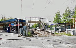
Stanford-le-Hope railway station
| Stanford-le-Hope |
|
|---|---|
 |
|
| Location | |
| Place | Stanford-le-Hope |
| Local authority | Borough of Thurrock |
| Grid reference | TQ682822 |
| Operations | |
| Station code | SFO |
| Managed by | c2c |
| Number of platforms | 2 |
| DfT category | D |
| Live arrivals/departures, station information and onward connections from National Rail Enquiries |
|
| Annual rail passenger usage* | |
| 2011/12 |
|
| 2012/13 |
|
| 2013/14 |
|
| 2014/15 |
|
| 2015/16 |
|
| History | |
| Key dates | Opened 1854 |
| National Rail – UK railway stations | |
| * Annual estimated passenger usage based on sales of tickets in stated financial year(s) which end or originate at Stanford-le-Hope from Office of Rail and Road statistics. Methodology may vary year on year. | |
|
|
|
Stanford-le-Hope railway station is on a loop line on the London, Tilbury and Southend Railway, serving the village of Stanford-le-Hope, Essex. It is 27 miles 13 chains (43.7 km) down-line from London Fenchurch Street via Rainham and it is situated between East Tilbury and Pitsea. Its three-letter station code is SFO.
It was opened on September 1854 with the name Horndon, when the line was extended to Low Street (now closed), terminating at Stanford-le-Hope until the next section of railway was opened a year later. The original station was constructed to the north of the London Road level crossing. The station was rebuilt during the 1960s immediately south of London Road by British Rail. The former station site is now the car-park.
Stanford-le-Hope is on a link known as the Tilbury Loop, which joins the main line at the London end at Barking and at the country end at Pitsea. The station and all trains serving it are operated by c2c.
Nearby DP World London Gateway, while principality a deep-water port, is also a rail cargo terminus.
The typical off-peak service consists of:
Coordinates: 51°30′50″N 0°25′23″E / 51.514°N 0.423°E
...
Wikipedia
