Tecámac
| Tecámac | ||
|---|---|---|
| Town & Municipality | ||
|
||
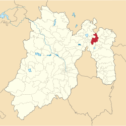
 Location of the municipality in Mexico State |
||
| Location in Mexico | ||
| Coordinates: 19°42′47″N 98°58′06″W / 19.71306°N 98.96833°WCoordinates: 19°42′47″N 98°58′06″W / 19.71306°N 98.96833°W | ||
| Country |
|
|
| State |
|
|
| Region | Ecatepec Region | |
| Metro area | Greater Mexico City | |
| Municipal Status | September 12, 1825 | |
| Municipal Seat | Tecámac de Felipe Villanueva | |
| Government | ||
| • Type | Ayuntamiento | |
| • Municipal President | Rocío Díaz Montoya | |
| Area | ||
| • Total | 157.34 km2 (60.75 sq mi) | |
| • Land | 157.34 km2 (60.75 sq mi) | |
| • Water | 0.00 km2 (0.00 sq mi) | |
| Elevation | 2,260 m (7,410 ft) | |
| Population (2010) | ||
| • Total | 364,579 | |
| Time zone | CST (UTC-6) | |
| • Summer (DST) | CDT (UTC-5) | |
| Postal code (of seat) | 55740 | |
| Area code(s) | 55 | |
| Demonym | Tecamaquense | |
| Website | Official website (Spanish) | |
Tecámac is a municipality in State of Mexico in Mexico. The municipality covers an area of 157.34 km². The municipal seat lies in the town (locality) of Tecámac de Felipe Villanueva. Its largest town, Ojo de Agua, with a population of 242,283 inhabitants, is the largest locality in Mexico that is not a municipal seat.
As of the 2010 census, the municipality had a total population of 364,579 inhabitants.
The town of Tecámac de Villanueva, a municipal seat, has governing jurisdiction over the following communities: Ozumbilla, Santa María Ajoloapan, San Lucas Xolox, Los Reyes Acozac and Ojo de Agua. The total municipality extends 157.34 km2 and borders with the municipalities of Zumpango, Temascalapa, Tonanitla, Teotihuacán and Ecatepec de Morelos.
The largest localities (cities, towns, and villages) are:
...
Wikipedia


