Teign
| River Teign | |
|
The Teign estuary at sunset
|
|
| Country | England |
|---|---|
| County | Devon |
| Tributaries | |
| - left | Blackaton Brook, Fingle Brook, Reedy Brook, Sowton Brook, Bramble Brook, Kate Brook |
| - right | Beadon Brook, River Bovey, River Lemon, Aller Brook |
| Towns | Teignmouth; Newton Abbot |
| Source | |
| - elevation | 528 m (1,732 ft) |
| - coordinates | 50°38′19″N 003°57′31″W / 50.63861°N 3.95861°W |
| Mouth | Lyme Bay |
| - location | English Channel |
| - elevation | 0 m (0 ft) |
| - coordinates | 50°32′23″N 3°30′2″W / 50.53972°N 3.50056°WCoordinates: 50°32′23″N 3°30′2″W / 50.53972°N 3.50056°W |
| Length | 50 km (31 mi) |
|
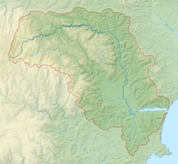
Map showing the course and catchment of the Teign.
|
|
The River Teign /ˈteɪn/ or /ˈtiːn/ is a river in the county of Devon, England. It is 50 km (31 mi) long and rises on Dartmoor, becomes an estuary just below Newton Abbot and reaches the English Channel at Teignmouth.
The river-name 'Teign' is first attested in an Anglo-Saxon charter of 739, where it appears as Teng. The name is pre-Roman, related to the Welsh taen meaning 'sprinkling', and means simply 'stream'.
The river lends its name to several places, including Teigncombe, Drewsteignton, Canonteign, Teigngrace, Kingsteignton (at one time, one of England's largest villages), Bishopsteignton, Teignharvey, and the second largest settlement along its course, Teignmouth. However, the villages of Combeinteignhead and Stokeinteignhead, on the other side of the estuary from Bishopsteignton, are not named after the river.
The River Teign rises on Dartmoor, as do many other major Devon rivers. It has two separate sources: one rises at Teign Head, forming the North Teign which flows northeast where it is crossed by a clapper bridge near Teigncombe. On its bank near the confluence with the Walla Brook is the Tolmen Stone that is perforated by a large circular hole. The second source rises near Grey Wethers and forms the shorter South Teign which flows through the Fernworthy Forest and a reservoir of the same name. The two rivers combine at Leigh Bridge near Chagford to form the Teign, which leaves the moor on its eastern side, flowing beneath Castle Drogo in a steep-sided valley. Near Dunsford there is a nature reserve on the east bank.
...
Wikipedia


