Telford and Wrekin
| Telford and Wrekin | |
|---|---|
| Unitary authority area, Borough | |
| Nickname(s): Telford | |
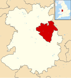
 Telford and Wrekin shown within Shropshire and England |
|
| Coordinates: 52°40′52″N 2°26′19″W / 52.68111°N 2.43861°WCoordinates: 52°40′52″N 2°26′19″W / 52.68111°N 2.43861°W | |
| Country | United Kingdom |
| Region | West Midlands |
| County | Shropshire |
| Government | |
| Area | |
| • Total | 112.09 sq mi (290.31 km2) |
| Population | |
| • Total | 166,800 |
| • Density | 1,500/sq mi (570/km2) |
| Time zone | GMT |
| ISO 3166 code | 01952 |
Telford and Wrekin is a unitary district with borough status in the West Midlands region of England. The district was created in 1974 as The Wrekin, then a non-metropolitan district of Shropshire. In 1998 the district became a unitary authority and was renamed Telford and Wrekin. It remains part of the Shropshire ceremonial county and shares institutions such as the Fire and Rescue Service and Community Health with the rest of Shropshire.
The borough's major settlement is Telford, a new town designated in the 1960s incorporating the existing towns of Dawley, Madeley, Oakengates and Wellington. The next largest population centre is Newport, a market town to the north of Telford.
The borough borders Staffordshire, but is mostly surrounded by the non-metropolitan county of Shropshire, whose unitary authority is Shropshire Council. For Eurostat purposes it is a NUTS 3 region (code UKG21) and is one of four unitary authority areas that comprise the "Shropshire and Staffordshire" NUTS 2 region.
...
Wikipedia
