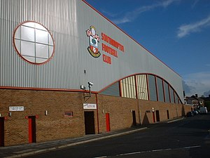
The Dell (Southampton F.C.)

Exterior of the Dell in 2000
|
|
| Location | Milton Road, Southampton, Hampshire, England |
|---|---|
| Coordinates | 50°54′53″N 001°24′47″W / 50.91472°N 1.41306°WCoordinates: 50°54′53″N 001°24′47″W / 50.91472°N 1.41306°W |
| Owner | Southampton Leisure Holdings PLC |
| Operator | Southampton F.C. |
| Capacity | 15,200 |
| Surface | Grass |
| Construction | |
| Broke ground | 1897 |
| Opened | September 1898 |
| Expanded | 1927, 1929, 1980s, 1990s |
| Closed | May 2001 |
| Demolished | June – July 2001 |
| Construction cost | £7,000 – £9,000 |
| Architect | Archibald Leitch (the West Stand) |
| Tenants | |
| Southampton F.C. (1898–2001) | |
The Dell in Milton Road, Southampton, Hampshire, England was the home ground of Southampton F.C. between 1898 and 2001.
Since 1896, Southampton had been tenants of Hampshire County Cricket Club at the County Ground, having vacated the Antelope Ground in the summer of 1896. The rent payable to the cricket club (£200 p.a.) was putting a strain on the football club's finances and, in an attempt to reduce this burden, the club had considered a merger with the Freemantle club and a move to their ground in Shirley. The merger proposals had fallen through, but at the Extraordinary general meeting in June 1897, the members were informed that "the committee had a ground in view".
At a shareholders' meeting on 11 November 1897, the chairman stated:
. . . that all being well, by next season the company would be in possession of its own ground which was at the present time in the hands of George Thomas Esq. who was devoting his time to its early completion.
Although the minutes do not record the location of the new ground, it was common knowledge within the town that the new ground was situated
. . . in the dell that is not far from the County Ground, and nearer West Station and the town, and at the present time it is a narrow valley with a stone culvert running along the bottom. It will not be a large ground, but the natural banks on all sides will be a great help in arranging for the convenience of the spectators.
The site on which the ground was built was described in Philip Brannon's Picture of Southampton, published in 1850, as "a lovely dell with a gurgling stream and lofty aspens"; the stream is the Rollsbrook which flows out of Southampton Common, running parallel to Hill Lane before now disappearing under Commercial Road and the Central Station, from where it is conduited under Southampton Docks into Southampton Water. The land had been purchased in the 1880s by the Didcot, Newbury and Southampton Railway to enable them to continue their line from Winchester via Twyford, Chandlers Ford, a tunnel at Chilworth and Shirley where it was to pass to the North East of what is now St James' Park, Southampton and St. James' Church. From here the line would have travelled south across Hill Lane to run through the dell and onto an embankment leading to a viaduct over Commercial Road and the London and South Western Railway line before terminating on the Western Esplanade North of the Royal Pier., The dell was stripped of vegetation and the stream channelled into a conduit with work started on the embankment, which survives behind property to the North of Commercial Road but was never used,and the viaduct which was part built but later demolished. The project was abandoned at this point and agreement reached to connected to the London and South Western Railway at Shawford Junction with running rights into Southampton.
...
Wikipedia
