Thomaston, GA
| City of Thomaston | |
|---|---|
| City | |
| Motto: "One of the Best 100 Towns" | |
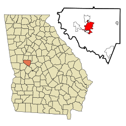
 Location in Upson County and the state of Georgia. |
|
| Coordinates: 32°54′N 84°20′W / 32.900°N 84.333°WCoordinates: 32°54′N 84°20′W / 32.900°N 84.333°W | |
| Country | United States |
| State | Georgia |
| County | Upson |
| Area | |
| • Total | 9.2 sq mi (23.8 km2) |
| • Land | 9.1 sq mi (23.4 km2) |
| • Water | 0.1 sq mi (0.4 km2) |
| Elevation | 784 ft (239 m) |
| Population (2006) | |
| • Total | 9,638-(14,898 with Sunset Village, Lincoln Park, and Hannahs Mills included.) |
| • Density | 1,022.9/sq mi (395.4/km2) |
| Time zone | Eastern (EST) (UTC-5) |
| • Summer (DST) | EDT (UTC-4) |
| ZIP code | 30286 |
| Area code(s) | 706 |
| FIPS code | 13-76168 |
| GNIS feature ID | 0324093 |
| Website | Official City of Thomaston, Georgia Government Website |
Thomaston is a city in and the county seat of Upson County,Georgia, United States. The population was 9,638 at the 2006 census. It is the principal city of and is included in the Thomaston, Georgia Micropolitan Statistical Area, which is included in the Atlanta - Sandy Springs (GA) - Gainesville (GA) - Alabama (partial) Combined Statistical Area.
Thomaston is located on US Route 19 and State Route 3, which run north and south, and on State Routes 36 and 74, which run (more or less) east and west.
Thomaston was incorporated on January 1, 1825, and designated as the seat of Upson County. The town was named for General Jett Thomas, an Indian fighter in the War of 1812. Jett is also credited with assisting in the construction of the state capitol at Milledgeville in 1805-7 and Franklin College on the campus of the University of Georgia in 1806.
The town was laid out with parallel streets running north and south, east and west, with the courthouse square in the center of town.
The judges of the inferior court had the authority to sell lots to individuals on a one-third cash basis with two years to complete the payment. This money was used to build the first courthouse, which was completed in 1828. The second courthouse was completed in 1852, and the present courthouse was erected in 1908. In the southeast corner of the square is a cannonball mounted on a marble base, said to be the first fired at Fort Sumter, off the coast of Charleston, South Carolina. P. W. Alexander, a noted correspondent during the Civil War (1861–65) and a citizen of Upson County, retrieved it.
A few miles south of the square is one of the oldest houses in Thomaston, the Pettigrew-White-Stamps House. Built by John E. Pettigrew in 1833, it currently serves as the Upson Historical Society Museum. The African American Museum is housed in a late 1920s three-room shotgun-style house.
The Civil War erupted on Thomaston's soil on April 18, 1865, nine days after Confederate general Robert E. Lee's surrender at Appomattox, Virginia, when Union cavalry raiders moving from Columbus to Macon embarked on three days of devastation in Upson County. The raiders, led by Major General James Harrison Wilson, looted homes, destroyed three of Upson's cotton mills, and set fire to a steam locomotive. In 1866 Thomaston's African Americans held an emancipation celebration, which has continued every year since; celebrated in May, it is the country's longest-running commemoration of freedom from slavery.
...
Wikipedia
