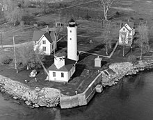
Tibbetts Point Light

Tibbetts Point Lighthouse
|
|
| Location | Tibbetts Point on Lake Ontario at the St Lawrence River |
|---|---|
| Coordinates | 44°6′00″N 76°22′12″W / 44.10000°N 76.37000°WCoordinates: 44°6′00″N 76°22′12″W / 44.10000°N 76.37000°W |
| Year first lit | 1854 |
| Foundation | Natural/Emplaced |
| Construction | Brick/Stucco |
| Tower shape | Conical frustum |
| Markings / pattern | White w/ Black Lantern |
| Height | 58 feet (18 m) |
| Focal height | 69 feet (21 m) |
| Original lens | Fourth Order Fresnel lens |
| Current lens | original lens |
| Range | 16 nautical miles (30 km; 18 mi) |
| Characteristic | Occulting White (Oc W 10s) |
| Admiralty number | H2836 |
| ARLHS number | USA-848 |
| USCG number | 7-1735 |
|
[]
|
|
The Tibbetts Point Lighthouse is located in Cape Vincent (town), New York. The land upon which the lighthouse stands is a part of a 600-acre (240 ha) grant of land to Captain John Tibbetts of Troy, New York. The lighthouse is a circular tower that stands 69 feet (21 m) above the water
The current lighthouse was constructed in 1854.
The Tibbetts Point Lighthouse is on the Great Lakes Seaway Trail.
Its Fresnel lens is still used. Only 70 such lenses are still operational in the United States, 16 being on the Great Lakes of which two are in New York.
Tibbetts Point Light is listed on the National Register of Historic Places, reference number 84002412, as Tibbets Point Light (US Coast Guard / Great Lakes TR).
The Archives Center at the Smithsonian National Museum of American History has a collection (#1055) of souvenir postcards of lighthouses and has digitized 272 of these and made them available online. These include postcards of Tibbetts Point Light with links to customized nautical charts provided by National Oceanographic and Atmospheric Administration.
DeWire, Elinor, "Tibbets Point Lighthouse." Mariners Weather Log (Fall 1991), pp. 30–31.
...
Wikipedia

