Tigris
| Tigris | |
| River | |
|
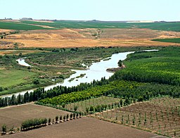
About 100 km from its source, the Tigris enables rich agriculture outside Diyarbakır, Turkey.
|
|
| Countries | Turkey, Syria, Iraq |
|---|---|
| Tributaries | |
| - left | Batman, Garzan, Botan, Khabur, Greater Zab, Lesser Zab, 'Adhaim, Cizre, Diyala |
| - right | Wadi Tharthar |
| Cities | Diyarbakır, Mosul, Baghdad |
| Source | Lake Hazar |
| - elevation | 1,150 m (3,773 ft) |
| - coordinates | 38°29′0″N 39°25′0″E / 38.48333°N 39.41667°E |
| Mouth | Shatt al-Arab |
| - location | Al-Qurnah, Basra Governorate, Iraq |
| Length | 1,850 km (1,150 mi) |
| Basin | 375,000 km2 (144,788 sq mi) |
| Discharge | for Baghdad |
| - average | 1,014 m3/s (35,809 cu ft/s) |
| - max | 2,779 m3/s (98,139 cu ft/s) |
| - min | 337 m3/s (11,901 cu ft/s) |
The Tigris (/ˈtaɪɡrɪs/) is the eastern member of the two great rivers that define Mesopotamia, the other being the Euphrates. The river flows south from the mountains of southeastern Turkey through Iraq and empties itself into the Persian Gulf.
The Tigris is 1,850 km long, rising in the Taurus Mountains of eastern Turkey about 25 km southeast of the city of Elazig and about 30 km from the headwaters of the Euphrates. The river then flows for 400 km through Turkish territory before becomh]] and Al-Kahla), which feeds the Hawizeh Marshes. The main channel continues southwards and is joined by the Al-Kassarah, which drains the Hawizeh Marshes. Finally, the Tigris joins the Euphrates near al-Qurnah to form the Shatt-al-Arab. According to Pliny and other ancient historians, the Euphrates originally had its outlet into the sea separate from that of the Tigris.
Baghdad, the capital of Iraq, stands on the banks of the Tigris. The port city of Basra straddles the Shatt al-Arab. In ancient times, many of the great cities of Mesopotamia stood on or near the Tigris, drawing water from it to irrigate the civilization of the Sumerians. Notable Tigris-side cities included Nineveh, Ctesiphon, and Seleucia, while the city of Lagash was irrigated by the Tigris via a canal dug around 2400 B.C.
...
Wikipedia


