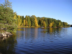
Toke (lake)
| Toke | |
|---|---|
 |
|
| Location | Bamble, Kragerø, Drangedal (Telemark) |
| Coordinates | 59°1′54″N 9°12′28″E / 59.03167°N 9.20778°ECoordinates: 59°1′54″N 9°12′28″E / 59.03167°N 9.20778°E |
| Basin countries | Norway |
| Surface area | 30.77 km2 (11.88 sq mi) |
| Max. depth | 147 m (482 ft) (Rørholtfjorden) |
| Shore length1 | 185.50 km (115.26 mi) |
| Surface elevation | 60.35–55.75 m (198.0–182.9 ft), regulated |
| References | NVE |
| 1 Shore length is not a well-defined measure. | |
Toke is a lake in Drangedal municipality in Telemark, Norway, consisting of Upper and Lower Toke, which is connected via "Straumen" - "the stream". At the north end of Upper Toke is the town center Prestestranda. In the south, Lower Toke reaches into Bamble (Rørholtfjorden) and into Kragerø, where its outlet is in Lundereidelva at the Dalfoss hydroelectric plant. The lake, with its inflow, constitutes the majority of the Kragerø watershed.
With a surface of about 19 square miles (49 km2) and a drainage basin of 770 square miles (2,000 km2), Toke is a substantial body of water in Telemark. The approximately 115 mile (185 km)-long shoreline, a large part of which consists of an old lakebed with deposits of silt, is strongly exposed to erosion because of development for power production. With its long shoreline and innumerable larger and smaller islands and narrow bays, Toke is a popular destination for boaters and sportsfishermen. Trout, Arctic char, whitefish, and perch are all found in the lake.
After the last Ice Age, about 9,500 years ago, the sea along the coast of Telemark was about 330 feet (100m) higher than today. Where Toke is currently, Drangedalsfjorden reached about 27 miles (60 km) onto land from Kragerø, through Drangedal, and up to Bø in Tørdal. The land rose quickly after the weight of the ice had gone. After about 1,000 years Toke became a lake, as it is known today. At the bottom of Rørholtfjorden, about 295 feet (90m) under the surface of the sea, a 32–40 foot (10-12m) layer of saltwater still exists from that time.
Since the arrival of man in the area about 9,000 years ago, Toke has served as a main artery between the sea and the inland. Signs from the Stone Age are found spread along the banks and on the islands of the lake. Cairns from the Bronze Age and Iron Ages are a common sight along the water's edge.
...
Wikipedia
