Tomotley
|
Tomotley Site
|
|

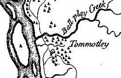
Tomotley on Henry Timberlake's 1762 "Draught of the Cherokee Country"
|
|
| Location | Monroe County, Tennessee |
|---|---|
| Nearest city | Vonore |
| Coordinates | 35°34′13″N 84°11′10″W / 35.57028°N 84.18611°WCoordinates: 35°34′13″N 84°11′10″W / 35.57028°N 84.18611°W |
| Built | circa 1000 A.D., 1751 A.D. |
| NRHP Reference # | 78002617 |
| Added to NRHP | 1978 |
Tomotley (also known as Tamahli) is a prehistoric and historic Native American site in Monroe County, Tennessee, in the southeastern United States. Occupied as early as the Archaic period, the Tomotley site had the most substantial periods of habitation during the Mississippian period, likely when the earthwork mounds were built, and later during the mid to late eighteenth century as a refugee village of Cherokee from the Lower, Middle and Valley towns.
The Tomotley site is now submerged by Tellico Lake, an impoundment of the Little Tennessee River managed by the Tennessee Valley Authority. The site is visible from Toqua Beach and the Toqua Boat Ramp, both of which are managed by the Tennessee Wildlife Resources Agency.
The Little Tennessee River traverses northern Monroe County for roughly 40 miles (64 km) between its Calderwood Lake impoundment near the Tennessee-North Carolina border and its mouth along the Tennessee River near Lenoir City. The impoundment of the river in 1979 by Tellico Dam created Tellico Lake, which covers the river's lower 33 miles (53 km) as well as the lower 22 miles (35 km) of its tributary, the Tellico River. The Tomotley site was situated along the south bank of the Little Tennessee just north of the river's confluence with Toqua Creek, nearly 22 miles (35 km) above the river's mouth along the Tennessee. The Overhill Cherokee village of Toqua and its associated prehistoric site was located on the south side of Toqua Creek, opposite Tomotley.
...
Wikipedia
