Topo (Calheta)
| Topo | |
| Nossa Senhora do Rosário | |
| Civil Parish | |
|
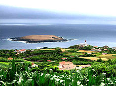
The islet of the parish of Topo is the extreme easterly extension of the island of São Jorge, as seen from the villa of Topo
|
|
| Official name: Freguesia do Topo (Nossa Senhora do Rosário) | |
| Name origin: Portuguese for extreme point | |
| Nickname: Vila do Topo | |
| Country | |
|---|---|
| Autonomous Region | |
| Island | São Jorge |
| Municipality | Calheta |
| Localities | Engenho, Levada, Lomba, Pontinha, São Pedro, Topo |
| Center | Topo |
| - elevation | 136 m (446 ft) |
| - coordinates | 38°32′55″N 27°46′3″W / 38.54861°N 27.76750°WCoordinates: 38°32′55″N 27°46′3″W / 38.54861°N 27.76750°W |
| Highest point | Cabeção |
| - location | Cume dos Arrebentões |
| - elevation | 558 m (1,831 ft) |
| - coordinates | 38°34′8″N 27°48′45″W / 38.56889°N 27.81250°W |
| Lowest point | Sea level |
| - location | Atlantic Ocean |
| - elevation | 0 m (0 ft) |
| Area | 9.24 km2 (4 sq mi) |
| - urban | .43 km2 (0 sq mi) |
| Population | 508 (2011) |
| Density | 56.94/km2 (147/sq mi) |
| Settlement | c. 1480 |
| LAU | Junta Freguesia |
| - location | Rua Joaquim H. Noronha |
| Timezone | Azores (UTC-1) |
| - summer (DST) | Azores (UTC0) |
| Postal Zone | 9875-165 |
| Area Code & Prefix | (+351) 292 XXX-XXXX |
| Patron Saint | Nossa Senhora do Rosário |
| Geographic detail from Instituto Geográfico Português (2010) | |
Topo, also known as Nossa Senhora do Rosário, is a civil parish on the northeastern corner of the municipality Calheta on the island of São Jorge. It is considered the first settlement on the island of São Jorge to attain the status of municipality; from 1510 to 1867 "Vila do Topo" was the municipal seat of Topo, which included the neighboring parish of Santo Antão. The population in 2011 was 508, in an area of 9.24 km².
Debate still exists on whether Topo was the first settlement on the island; the first colony was founded between 1480 and 1490, when a colony of Flemish people, under the direction of Willem van der Haegen, settled on the eastern coast. This adventurous Fleming, who later adopted the name "Guilherme da Silveira", and whose descendants populate the numerous villages of São Jorge, was later buried in the chapel-annex of the Solar dos Tiagos. Due to its proximity to Terceira, and owing to the difficult overland links to Calheta (over the Serra do Topo), the village was always more closely tied to Angra do Heroísmo: inter-marriage existed between both communities and the residents of Angra saw Topo as an extension of the city of Angra. This proximity is visible in similar architectural styles, which are different then the other communities of São Jorge.
Until the middle of the 20th century, port of Topo was a referential point in the maritime connection with Terceira due to its location. Although this coast was punctuated by steep cliffs, a staircase to the Cais velho and successive remodelling (between 1560 and 1637) allowed access to the village by sea. The port, and its access to Terceira, was so important that after the villages annexation by Calheta, the construction of the first lighthouse was deliberated in favour of Topo.
Due to its population growth, the community was elevated to the status of village on September 12, 1510, transforming itself into one of the Captaincies of the island. Unfortunately, its further growth was curtailed by its limited hinterland, which would not allow further expansion economically. In fact, the village of Topo, until the middle of the 20th century did not have an adequate overland link to the rest of the island, and relied on its port. In the October 24, 1855 rationalization of the administrative divisions of the Azores, the municipality of Topo was disincorporated and merged into the administration of the municipality of Calheta (on April 1, 1870)
...
Wikipedia

