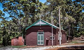
Torbay, Western Australia
|
Torbay Western Australia |
|
|---|---|

Torbay Agricultural Hall, opened 25 July 1912
|
|
| Coordinates | 35°01′00″S 117°38′00″E / 35.01667°S 117.63333°ECoordinates: 35°01′00″S 117°38′00″E / 35.01667°S 117.63333°E |
| Population | 336 (2011 census) |
| Established | 1889 |
| Postcode(s) | 6330 |
| Elevation | 69 m (226 ft) |
| Location | |
| LGA(s) | Albany |
| State electorate(s) | Albany |
| Federal Division(s) | O'Connor |
Torbay is a small town and a bay in the Great Southern region of Western Australia, 20 kilometres (12 mi) west of Albany. Torbay is within the City of Albany local government area. The Torbay townsite was gazetted in 1910.
The Torbay area is on the eastern fringe of the karri forest region, and with some notable blocks of remnant tall forest. Large granite outcrops are also common. Beaches on the bay tend towards fine white sand. Where streams occur, they are clear but stained dark brown in colour from high-tannin-content vegetation.
Children in the area usually attend schools in Albany, travelling there by school bus. There is also a local independent school, the Woodbury Boston Primary School.
The town is named after Tor Bay, a bay on the coast to the south originally named by Captain Matthew Flinders in 1801 after Tor Bay in Devon, the home port of Admiral Richard Howe's Channel Fleet, for whom Flinders had served as a midshipman from 1793 to 1794. Admiral Howe's nickname was "Lord Torbay". Flinders identified a number of local features with Lord Howe-related names, including Torbay (the bay), Torbay Inlet, Torbay Head and West Cape Howe (originally named Cape Howe by George Vancouver), to avoid confusion with James Cook’s Cape Howe in New South Wales. Pre-settlement explorers of the Torbay area included: Matthew Flinders, Robert Brown, Ferdinand Bauer and William Westall (Dec. 1801);Thomas Wilson (Dec. 1829);Roe and Stirling (Nov. 1835); and Charles Codrington Forsyth of HMS Pelorus (1838).
...
Wikipedia

