Traveler's Rest (Lolo, Montana)
|
Traveler's Rest (Montana)
|
|

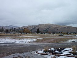
Countryside at Travelers Rest
|
|
| Nearest city | Lolo, Montana |
|---|---|
| Coordinates | 46°44′20″N 114°04′50″W / 46.73889°N 114.08056°WCoordinates: 46°44′20″N 114°04′50″W / 46.73889°N 114.08056°W |
| Built | 1805 |
| NRHP reference # | 66000437 |
| Significant dates | |
| Added to NRHP | October 15, 1966 |
| Designated NHL | October 9, 1960 |
Traveler's Rest was a stopping point of the Lewis and Clark Expedition, located about one mile south of Lolo, Montana. The expedition stopped from September 9 to September 11, 1805, before crossing the Bitterroot Mountains, and again on the return trip from June 30 to July 3, 1806. Traveler's Rest is at the eastern end of the Lolo Trail. It was declared a National Historic Landmark in 1960 and added to the National Register of Historic Places in 1966. The boundaries were subsequently revised, and mostly lie within the 51-acre (21 ha) Traveler's Rest State Park, which is operated by the Montana Fish, Wildlife & Parks. Significant archeological findings made in 2002, including latrine sites with traces of mercury and fire hearths, make this the only site on the Lewis and Clark National Historic Trail that has yielded physical proof of the explorers' presence. Records made by Lewis and Clark often spell "Traveler's" as "Traveller's". This spot is largely unchanged from the days of Lewis and Clark. From this location, Lewis and Clark split up to explore Montana during their return trip, not reuniting until they reached Sanish, North Dakota.
At the time of landmark designation in 1960, the exact location of the expedition's campsite was unknown. Boundaries were formalized on December 12, 1983. Subsequent investigations revealed that errors had been made in setting the boundaries of the landmark. Detailed historical and scientific investigations resulted in a 55-page request for boundary corrections, submitted on May 10, 2004, and approved on March 21, 2006. A new road and bridge were built in 2006.
After departing here in 1806, Lewis' part of the expedition traveled to what is now the Alice Creek Historic District.
...
Wikipedia


