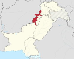
Tribal belt (Pakistan)
| Federally Administered Tribal Areas قبايلي سيمې قبائلی علاقہ جات |
|||
|---|---|---|---|
| Administrative Territory of Pakistan | |||
|
|||
 Location of the Federally Administered Tribal Areas |
|||
| Coordinates: 33°0′N 70°10′E / 33.000°N 70.167°ECoordinates: 33°0′N 70°10′E / 33.000°N 70.167°E | |||
| Country |
|
||
| Administrative unit | Federal territory | ||
| Administrative centre | Peshawar | ||
| Largest city | Parachinar | ||
| Area | |||
| • Total | 27,220 km2 (10,510 sq mi) | ||
| Population (2017) | |||
| • Total | 5,001,676 | ||
| • Density | 180/km2 (480/sq mi) | ||
| ISO 3166 code | PK-TA | ||
| Website | www |
||
The Federally Administered Tribal Areas (FATA; Pashto: قبایلي سیمې، منځنۍ پښتونخوا; Urdu: وفاقی منتظم شدہ قبائیلی علاقہ جات) is a semi-autonomous tribal region in northwestern Pakistan, consisting of seven tribal agencies (districts) and six frontier regions, and are directly governed by Pakistan's federal government through a special set of laws called the Frontier Crimes Regulations (FCR). It borders Pakistan's provinces of Khyber Pakhtunkhwa and Balochistan to the east and south, and Afghanistan's provinces of Kunar, Nangarhar, Paktia, Khost and Paktika to the west and north.
The territory is almost exclusively inhabited by the Pashtun, who also live in the neighbouring provinces of Khyber Pakhtunkhwa and Northern Balochistan; they are largely Muslims. The main towns of the territory are Parachinar, Miramshah, Razmak, Wanna, Jamrud, and Landi Kotal.
...
Wikipedia


