Tromelin Island
|
Tromelin Island
French: L'Île Tromelin
|
|
|---|---|

Flag
|
|
|
Motto: "Liberté, égalité, fraternité"
|
|
|
Anthem: La Marseillaise
|
|

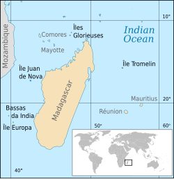
Location of the Scattered islands in the Indian Ocean.
KM=Comoros MG=Madagascar MU=Mauritius MZ=Mozambique RE=Réunion YT=Mayotte |
|
| Official languages | French |
| French overseas territory | |
|
• Discovery by Jean Marie Briand de la Feuillée
|
1722 |
|
• French claim to sovereignty
|
29 november 1776 |
| Currency | Euro (EUR) |
| ISO 3166 code | TF |
| Internet TLD | .tf |
Tromelin Island (/ˌtroʊmlɪn ˈaɪlənd/; French: Île Tromelin, pronounced: [il tʁɔmlɛ̃]) is a low, flat, strategic island in the Indian Ocean dedicated to French scientific investigations and expeditions. It is about 500 kilometers north of Réunion, and about 450 kilometres (280 mi) east of Madagascar. Tromelin is administered as a French overseas territory; however, Mauritius claims sovereignty over the island, on grounds of its absence in the listing of the 8th article of the French version of the Paris Treaty. France and Mauritius have been negotiating for years in regards to a possible co-management of the island in the future. Tromelin has facilities for scientific expeditions but also a strategic airplane landing track which could be used in a coordinated way with Diego Garcia US forces for advanced air and sea monitoring of the region in case of conflict. It also has a weather station and is a nesting site for boobies and green sea turtles. Tromelin Island has really deep waters with a large fish resource and may have important polymetallic nodules based on the presence of high value metals in the area such as cobalt mines at the same latitude in Madagascar in Ambatovy and important geological activity.
...
Wikipedia
