Tropic, Utah
| Tropic, Utah | |
|---|---|
| Town | |

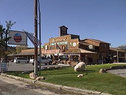
General store in Tropic (©2001 SW Clyde, courtesy of byways.org)
|
|
 Location in Garfield County and state of Utah |
|
| Coordinates: 37°37′25″N 112°5′19″W / 37.62361°N 112.08861°WCoordinates: 37°37′25″N 112°5′19″W / 37.62361°N 112.08861°W | |
| Country | United States |
| State | Utah |
| County | Garfield |
| Government | |
| • Mayor | Lowell Mecham |
| • Clerk | Marie Niemann |
| Area | |
| • Total | 8.39 sq mi (21.72 km2) |
| • Land | 8.37 sq mi (21.67 km2) |
| • Water | 0.02 sq mi (0.06 km2) |
| Elevation | 6,309 ft (1,923 m) |
| Population (2010) | |
| • Total | 530 |
| • Density | 63/sq mi (24.5/km2) |
| Time zone | Mountain (MST) (UTC-7) |
| • Summer (DST) | MDT (UTC-6) |
| ZIP code | 84776 |
| Area code(s) | 435 |
| FIPS code | 49-77560 |
| GNIS feature ID | 1446722 |
| Website | www |
Tropic is a town in Garfield County, Utah, United States, along Utah Scenic Byway 12. As of the 2010 census, the town had a population of 530. Tropic was founded in 1891.
Tropic is in southern Garfield County along Utah Route 12, 7.5 miles (12.1 km) southeast of Bryce Canyon City and 5 miles (8 km) north of Cannonville. It is in the Tropic Valley, drained by the Paria River, a tributary of the Colorado River.
According to the United States Census Bureau, the town has a total area of 8.4 square miles (21.7 km2), of which 0.02 square miles (0.06 km2), or 0.26%, are water.
The climate in this area has mild differences between highs and lows, and there is adequate rainfall year-round.
As of the census of 2000, there are 508 people in the town, organized into 160 households and 132 families. The population density is 60.6 people per square mile (23.4/km²). There are 206 housing units at an average density of 24.6 per square mile (9.5/km²). The racial makeup of the town is 96.06% White, 0.39% Native American, 1.38% from other races, and 2.17% from two or more races. There are no African Americans, Asians, or Pacific Islanders. 2.36% of the population are Hispanic or Latino of any race.
...
Wikipedia
