Tropical Storm Dolly (2014)
| Tropical storm (SSHWS/NWS) | |

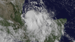
Tropical Storm Dolly approaching Mexico on September 2
|
|
| Formed | September 1, 2014 |
|---|---|
| Dissipated | September 4, 2014 |
| (Remnant low after September 3) | |
| Highest winds |
1-minute sustained: 50 mph (85 km/h) |
| Lowest pressure | 1000 mbar (hPa); 29.53 inHg |
| Fatalities | 1 indirect |
| Damage | $6.5 million (2014 USD) |
| Areas affected | Eastern and Northeastern Mexico, Texas |
| Part of the 2014 Atlantic hurricane season | |
Tropical Storm Dolly was a short-lived and disorganized tropical cyclone that caused moderate damage across Tamaulipas, Mexico, in early September 2014. Originating from a tropical wave, the system first became a tropical depression late on September 1 while situated over the Bay of Campeche. Dolly struggled against strong wind shear for the duration of its existence. The large system featured multiple circulations, sometimes becoming a new dominant center and other times simply rotating around a mean vortex. As a result, multiple center relocations occurred along its general west-northwest track. Dolly eventually made landfall in Tamaulipas on September 3 before degenerating into a remnant low. The system subsequently dissipated the following day.
Prior to Dolly's landfall, schools suspended classes and officials opened shelters across Tamaulipas and Veracruz. The storm produced widespread moderate to heavy rain in Mexico, with accumulations peaking at 15.23 in (387 mm) in La Encantada, Tamaulipas. Subsequent flooding caused damage amounting to at least 87 million pesos (US$6.5 million). One fatality was indirectly attributed to the storm. Moisture from Dolly also brought scattered storms to southern Texas.
On August 19, 2014, a tropical wave emerged off the west coast of Africa. The system traversed the Atlantic over the next week with no signs of development. Convection finally increased once the wave entered the Caribbean Sea on August 27; however, it was not until August 30 when interaction with a Kelvin wave spurred organization. An area of low pressure consolidated within the system as it crossed the Yucatán Peninsula on August 31. Formation of a banding feature along the southeastern portion of the circulation on September 1 marked the system's transition into a tropical depression by 18:00 UTC while over the Bay of Campeche. Although situated over warm waters of 30 °C (86 °F), strong wind shear created an unfavorable environment and hindered intensification. During this formative stage, the depression tracked northward as its center relocated before turning to the northwest and later west. It was uncertain if a closed circulation truly existed due to conflicting data and the depression could have remained a trough until the afternoon of September 2.
...
Wikipedia
