Tumalo State Park
| Tumalo State Park | |
|---|---|

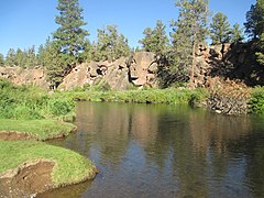
The Deschutes River at the park
|
|
| Type | Public, state |
| Location | Deschutes County, Oregon |
| Nearest city | Bend, Oregon |
| Coordinates | 44°07′37″N 121°19′55″W / 44.1270619°N 121.3319784°WCoordinates: 44°07′37″N 121°19′55″W / 44.1270619°N 121.3319784°W |
| Area | 330 acres (130 ha) |
| Created | 1954 |
| Operated by | Oregon Parks and Recreation Department |
Tumalo State Park is a well-developed state park in Deschutes County, Oregon, United States. Established in 1954, the park is located northwest of the city of Bend and along the Deschutes River at a site home to many bird species. The park is popular for picnics, swimming, fishing, hiking, and camping, and is open year-round.
Tumalo State Park was established in 1954. It is located approximately 5 miles (8.0 km) northwest of Bend. The park preserved a scenic portion of the Deschutes River where basalt cliffs extend down to the river. It also created a day-use picnic area and a public campground.
The original 115 acres (47 ha) were given to the State of Oregon by Deschutes County. Minor property adjustments have been made over the years. In 1959, the state returned 1 acre (0.40 ha) to the county for a road right of way across the southern part of park. The road connected residents living south of the park with the old highway. In 1960, the state purchased an additional 3.5 acres (1.4 ha). A year later, the state granted another road easement to the county, allowing Johnson Road to cross the western corner of the park. This reduced the park's area by 0.8 acres (0.32 ha). In 1963, a third road right of way reduced it by another 0.7 acres (0.28 ha). In 1972, the county gave an additional 191 acres (77 ha) to the state to expand the park. Additional land purchases and exchanges over the next decade brought the total park property to 330 acres (130 ha).
Tumalo State Park is located in the Deschutes River canyon, running along both sides of the river. The park land on the east side of the river is mostly level with a gentle upward slope toward the east. The slope becomes much steeper at the eastern edge of the park. On the west side of the river, the park land is for the most part level.
The park landscape is generally open with a light tree cover, mainly western juniper with some ponderosa pine. In the undeveloped parts of the park, big sagebrush is the main ground cover. There are willow, dogwood, alder, and poplar along the river banks.
...
Wikipedia

