Vernon County, Missouri
| Vernon County, Missouri | |
|---|---|
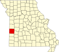
 Location in the U.S. state of Missouri |
|
 Missouri's location in the U.S. |
|
| Founded | February 27, 1855 |
| Named for | Colonel Miles Vernon, state senator, and veteran of the Battle of New Orleans |
| Seat | Nevada |
| Largest city | Nevada |
| Area | |
| • Total | 837 sq mi (2,168 km2) |
| • Land | 826 sq mi (2,139 km2) |
| • Water | 10 sq mi (26 km2), 1.2% |
| Population (est.) | |
| • (2015) | 20,826 |
| • Density | 26/sq mi (10/km²) |
| Congressional district | 4th |
| Time zone | Central: UTC-6/-5 |
| Website | www |
| Vernon County, Missouri | ||||
|---|---|---|---|---|
| Elected countywide officials | ||||
| Assessor | Cherie K. Roberts | Democratic | ||
| Circuit Clerk | Vickie Erwin | Democratic | ||
| County Clerk | Mike Buehler | Republican | ||
| Collector | Phil Couch | Democratic | ||
|
Commissioner (Presiding) |
Joe Hardin | Republican | ||
|
Commissioner (District 1) |
Neal F. Gerster | Democratic | ||
|
Commissioner (District 2) |
Everett Wolf | Republican | ||
| Coroner | David L. Ferry | Democratic | ||
| Prosecuting Attorney | Brandy McInroy | Republican | ||
| Public Administrator | Tammy Bond | Democratic | ||
| Recorder | Doug Shupe | Republican | ||
| Sheriff | Jason Mosher | Republican | ||
| Surveyor | Jerry Wood | Republican | ||
| Treasurer | Phil Couch | Democratic | ||
| Vernon County, Missouri | ||
|---|---|---|
| 2008 Republican primary in Missouri | ||
| John McCain | 705 (32.64%) | |
| Mike Huckabee | 920 (42.59%) | |
| Mitt Romney | 408 (18.89%) | |
| Ron Paul | 74 (3.43%) | |
| Vernon County, Missouri | ||
|---|---|---|
| 2008 Democratic primary in Missouri | ||
| Hillary Clinton | 1,434 (61.55%) | |
| Barack Obama | 732 (31.42%) | |
| John Edwards (withdrawn) | 124 (5.32%) | |
Vernon County is a county located in west central Missouri. As of the 2010 census, the population was 21,159. Its county seat is Nevada. The county was organized on February 27, 1855 and was named for Col. Miles Vernon (1786–1867), a state senator and veteran of the Battle of New Orleans.
Vernon County suffered considerable damage during the American Civil War. The courthouse was burned by Union Army soldiers on May 23, 1863, along with the entire town of Nevada. The present courthouse dates to 1907. Vernon County was one of four Missouri counties that were completely depopulated by Union General Thomas Ewing's notorious General Order No. 11 (1863). Most of the inhabitants would not be allowed to return to their homes until after the Civil War ended in May 1865.
According to the U.S. Census Bureau, the county has a total area of 837 square miles (2,170 km2), of which 826 square miles (2,140 km2) is land and 10 square miles (26 km2) (1.2%) is water.
As of the census of 2000, there were 20,454 people, 7,966 households, and 5,432 families residing in the county. The population density was 24 people per square mile (9/km²). There were 8,872 housing units at an average density of 11 per square mile (4/km²). The racial makeup of the county was 96.99% White, 0.61% Black or African American, 0.79% Native American, 0.31% Asian, 0.03% Pacific Islander, 0.31% from other races, and 0.95% from two or more races. Approximately 0.84% of the population were Hispanic or Latino of any race.
...
Wikipedia
