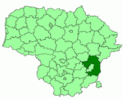
Vilnius district municipality
|
Vilnius District Municipality Vilniaus rajono savivaldybė |
||
|---|---|---|
| Municipality | ||
|
||
 Location of Vilnius district municipality |
||
| Country |
|
|
| Ethnographic region | Dzūkija/Aukštaitija | |
| County | Vilnius County | |
| Capital | Vilnius | |
| Elderships |
List
|
|
| Area | ||
| • Total | 2,129 km2 (822 sq mi) | |
| Population (2011 Census) | ||
| • Total | 95,348 | |
| • Density | 45/km2 (120/sq mi) | |
| Time zone | EET (UTC+2) | |
| • Summer (DST) | EEST (UTC+3) | |
| Website | www |
|
Vilnius District Municipality (Lithuanian: Vilniaus rajono savivaldybė) is one of 60 municipalities in Lithuania. It surrounds the capital city of Vilnius on 3 sides, while the rest borders the Trakai District Municipality.
At the 2011 Census, Poles amounted to 52.07% out of 95,348 inhabitants. 32.47% were Lithuanians, 8.01% Russians, 4.17% Belarusians, 0.65% Ukrainians and 0.11% Jews.
District structure.
Largest residential areas by population (2011):
Vilnius District Municipality is twinned with:
Coordinates: 54°44′N 25°23′E / 54.733°N 25.383°E
...
Wikipedia

