Vogesen
| Vosges | |
|---|---|

Location of the Vosges
|
|
| Highest point | |
| Peak | Grand Ballon (Alsatian: Großer Belchen) |
| Elevation | 1,424 m (4,672 ft) |
| Dimensions | |
| Length | 120 km (75 mi) |
| Area | 5,500 km2 (2,100 sq mi) up to 6,000 km2 (2,300 sq mi) depending on the natural region boundaries selected |
| Geography | |
| Country | France |
| Region | Grand-Est, Bourgogne-Franche-Comté |
| Range coordinates | 48°N 7°E / 48°N 7°ECoordinates: 48°N 7°E / 48°N 7°E |
| Geology | |
| Orogeny | Low mountain range |
| Age of rock |
Gneiss, granite and vulcanite stratigraphic units: about 419–252 mya Bunter sandstone stratigraphic unit: 252–243 mya |
| Type of rock | Gneiss, granite, vulcanite, sandstone |
Gneiss, granite and vulcanite stratigraphic units: about 419–252 mya
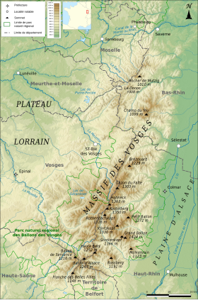
The Vosges (French pronunciation: [voʒ]; German: Vogesen [voˈɡeːzn̩]), also called the Vosges Mountains, are a range of low mountains in eastern France, near its border with Germany. Together with the Palatine Forest to the north on the German side of the border, they form a single geomorphological unit and low mountain range of around 8,000 km2 (3,100 sq mi) in area. It runs in a north-northeast direction from the Burgundian Gate (the Belfort–Ronchamp–Lure line) to the Börrstadt Basin (the Winnweiler–Börrstadt–Göllheim line), and forms the western boundary of the Upper Rhine Plain.
The Grand Ballon is the highest peak at 1,424 m (4,672 ft), followed by the Storkenkopf (1,366 m, 4,482 ft), and the Hohneck (1,364 m, 4,475 ft).
The elongated massif is divided south to north into three sections:
In addition, the term "Central Vosges" is used to designate the various lines of summits, especially those above 1,000 m (3,300 ft) in elevation. The French department of Vosges is named after the range.
...
Wikipedia

