Vorderrhein
| Vorderrhein | |
|---|---|

The Vorderrhein in the Ruinaulta gorge
|
|

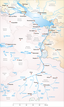
Area of the Alpine Rhine with its headwaters
|
|
| Native name | Rein Anteriur |
| Other name(s) | Anterior Rhine |
| Country | Switzerland |
| Canton | Canton of Graubünden |
| Basin features | |
| Main source |
Tujetsch 46°39′10″N 8°42′43″E / 46.65278°N 8.71194°E |
| River mouth |
Reichenau 585 m (1,919 ft) 46°49′24″N 9°24′28″E / 46.82333°N 9.40778°ECoordinates: 46°49′24″N 9°24′28″E / 46.82333°N 9.40778°E |
| Progression | Rhine → North Sea |
| River system | Rhine |
| Basin size | 1,512 km2 (584 sq mi) |
| Physical characteristics | |
| Length | 76 km (47 mi) |
| Discharge |
|
The Vorderrhein (German; English: Anterior Rhine; in the local Sursilvan language: Rein Anteriur) is one of the two sources of the Rhine. Its catchment area of 1,512 square kilometres (584 square miles) is located predominantly in the canton of Graubünden (Switzerland). The Vorderrhein is about 76 kilometres (47 mi) long, thus more than 5% longer than the Hinterrhein/Rein Posteriur (each measured to the farthest source). The Vorderrhein, however, has an average water flow of 53.8 m3/s (1,900 cu ft/s), which is less than the flow of the Hinterrhein. According to the Atlas of Switzerland of the Swiss Federal Office of Topography, the source of the Vorderrhein– and the Rhine –is located north of the Rein da Tuma and Lake Toma.
Vorderrhein was also the name of a judicial district that was created in 1851 with the reorganization of the judiciary of Graubünden. In 2001, it was annexed by the District Surselva.
The largest communities along the Vorderrhein are Disentis and Ilanz.
The Vorderrhein flows mostly in an east-northeast direction, through the Surselva, a large longitudinal valley. Its north side is steep, with short valleys, the southern side, however, is divided by some long valleys (similar to the situation in the Canton of Valais further west). Consequently, its main tributaries, the Rein da Sumvitg, the Glenner and the Rabiusa all come from the south. In its lower course the Vorderrhein flows through the Flims Rockslide, giving rise to the canyon country of the Ruinaulta. Near Reichenau, it joins the Hinterrhein to form the (Alpine) Rhine.
...
Wikipedia
