Waiapu Valley
|
Waiapu Valley Te Riu o Waiapu (Māori) |
|
|---|---|

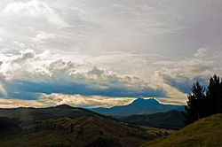
Waiapu Valley, with Mount Hikurangi in the centre right of the picture.
|
|
 |
|
| Coordinates: 37°59′S 178°7′E / 37.983°S 178.117°ECoordinates: 37°59′S 178°7′E / 37.983°S 178.117°E | |
| Country |
|
| Region | Gisborne Region |
| Electorate | East Coast |
| Government | |
| • MP | Anne Tolley (National) |
| • Mayor | Meng Foon |
| Population | |
| • Estimate (2002) | 2,000 |
| Time zone | NZST (UTC+12) |
| • Summer (DST) | NZDT (UTC+13) |
| Area code(s) | 06 |
Waiapu Valley, also known as the Waiapu catchment, Waiapu River valley or simply Waiapu, is a valley in the north of the Gisborne Region on the East Coast of the North Island of New Zealand. It is the catchment area for the Waiapu River and its tributaries, and covers 1,734 square kilometres (670 sq mi). The Raukūmara Range forms the western side of the valley, with Mount Hikurangi in the central west. The towns of Ruatōria and Tikitiki are in the north-east of the valley.
The vast majority of the catchment area lies within the Waiapu and Matakaoa wards of the Gisborne District Council, with the southernmost area in the Waikohu and Uawa wards. Some of the most Western points fall within the Coast Ward of the Opotiki District Council in the Bay of Plenty Region.
The area is of immense cultural, spiritual, economic, and traditional significance to the local iwi, Ngāti Porou, and in 2002 approximately 90% of its 2,000 inhabitants were Māori.
Waiapu Valley is sparsely inhabited, with a population density in 2002 of approximately 1.15/km2 (3.0/sq mi) — less than 8% of the national average at the time (approximately 14.71/km2 or 38.09/sq mi). The population of the valley is centred in Ruatōria, though the area contains a large number of small settlements. In the 2006 census, Ruatōria had a population of 756 — down 9.7% since 2001, and 94.8% of its population were Māori, with 46% of the population able to speak te reo Māori. The second largest town, Tikitiki, is the easternmost point on the New Zealand State Highway network.
...
Wikipedia

