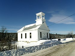
Walden, Vermont
| Walden, Vermont | |
|---|---|
| Town | |

Walden United Methodist Church
|
|
 Walden, Vermont |
|
| Location in the United States | |
| Coordinates: 44°28′48″N 72°14′46″W / 44.48000°N 72.24611°WCoordinates: 44°28′48″N 72°14′46″W / 44.48000°N 72.24611°W | |
| Country | United States |
| State | Vermont |
| County | Caledonia |
| Area | |
| • Total | 39.0 sq mi (100.9 km2) |
| • Land | 38.6 sq mi (99.9 km2) |
| • Water | 0.3 sq mi (0.9 km2) |
| Elevation | 1,683 ft (513 m) |
| Population (2010) | |
| • Total | 935 |
| • Density | 24/sq mi (9.4/km2) |
| Time zone | Eastern (EST) (UTC-5) |
| • Summer (DST) | EDT (UTC-4) |
| ZIP code | 05873 |
| Area code(s) | 802 |
| FIPS code | 50-75700 |
| GNIS feature ID | 1462238 |
Walden is a town in Caledonia County, Vermont, United States. The population was 935 at the 2010 census. The community has no ZIP code of its own; mail is routed through the West Danville and East Hardwick post offices.
According to the United States Census Bureau, the town has a total area of 39.0 square miles (100.9 km2), of which 38.6 square miles (99.9 km2) is land and 0.35 square miles (0.9 km2), or 0.91%, is water.Vermont Route 15 passes through the town, leading west to Hardwick and Morrisville and east to Danville. It is 17 miles (27 km) east via VT 15 and U.S. Route 2 to St. Johnsbury, Vermont.
The highest point in Walden is the summit of Stannard Mountain, near the town's northern border, with an elevation of over 2,579 feet (786 m) above sea level.
As of the census of 2000, there were 782 people, 301 households, and 219 families residing in the town. The population density was 20.2 people per square mile (7.8/km2). There were 499 housing units at an average density of 12.9 per square mile (5.0/km2). The racial makeup of the town was 98.21% White, 0.51% African American, 0.13% Native American, 0.13% from other races, and 1.02% from two or more races. Hispanic or Latino of any race were 0.26% of the population.
...
Wikipedia

