Walker River
| Walker River | |
| River | |
|
West Walker River near Leavitt Meadows
|
|
| Country | United States |
|---|---|
| State | Nevada |
| Cities | Yerington, Mason, Wabuska |
| Primary source | West Walker River |
| - location | Sierra Nevada, California |
| - elevation | 9,640 ft (2,938 m) |
| - coordinates | 38°08′24″N 119°30′28″W / 38.14000°N 119.50778°W |
| Secondary source | East Walker River |
| - location | Bridgeport Valley, California |
| - elevation | 6,570 ft (2,003 m) |
| - coordinates | 38°11′44″N 119°17′09″W / 38.19556°N 119.28583°W |
| Source confluence | |
| - location | Yerington, Lyon County, Nevada |
| - elevation | 4,442 ft (1,354 m) |
| - coordinates | 38°53′35″N 119°10′44″W / 38.89306°N 119.17889°W |
| Mouth | Walker Lake |
| - location | Mineral County, Nevada |
| - elevation | 3,973 ft (1,211 m) |
| - coordinates | 38°48′56″N 118°44′40″W / 38.81556°N 118.74444°WCoordinates: 38°48′56″N 118°44′40″W / 38.81556°N 118.74444°W |
| Length | 62 mi (100 km) |
| Basin | 3,134 sq mi (8,117 km2) |
| Discharge | for Wabuska, NV |
| - average | 164 cu ft/s (5 m3/s) |
| - max | 3,280 cu ft/s (93 m3/s) |
| - min | 0 cu ft/s (0 m3/s) |
|
Walker River and Walker Lake
|
|
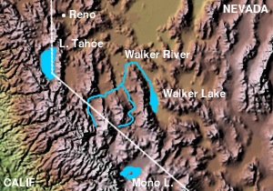
The Walker River is a river in west-central Nevada in the United States, approximately 62 miles (100 km) long. Fed principally by snowmelt from the Sierra Nevada mountains of California, it drains an arid portion of the Great Basin southeast of Reno and flows into the endorheic basin of Walker Lake. The river is an important source of water for irrigation in its course through Nevada; water diversions have reduced its flow such that the level of Walker Lake has fallen 160 feet (49 m) between 1882 and 2010. The river was named for explorer Joseph Reddeford Walker.
The Walker River is formed in southern Lyon County, 9 miles (14 km) south of Yerington, by the confluence of the East Walker and West Walker rivers. The West Walker River originates at Tower Lake in Mono County, California, 9,623 ft (2,933 m) above sea level in the Stanislaus National Forest. It flows north through a rugged canyon which provides the route for U.S. Route 395. It then emerges into Antelope Valley, where some water is diverted to the Topaz Lake reservoir, enters Nevada in Douglas County and turns northeast. It flows through Hoye Canyon into Lyon County, then across the Smith Valley, past Smith, and finally through Wilson Canyon into the Mason Valley where it joins the East Walker.
The East Walker River also begins in Mono County, California in the Bridgeport Valley, fed by several Sierra streams originating in the Hoover Wilderness including Buckeye, Robinson, Green and Virginia Creeks. After forming the Bridgeport Reservoir at the town of Bridgeport, the East Walker flows northeast into Nevada in Lyon County, receives Rough Creek and flows north, along the eastern edge of the Toiyabe National Forest before its confluence with the West Walker.
...
Wikipedia


