Wallingford, Pennsylvania
| Wallingford, Pennsylvania | |
| Settlement | |
|
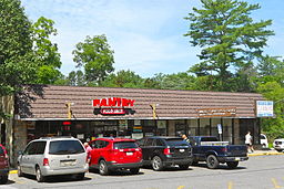
Wallingford post office
|
|
| Country | United States |
|---|---|
| State | Pennsylvania |
| County | Delaware |
| Township | Nether Providence |
| Elevation | 131 ft (39.9 m) |
| Coordinates | 39°53′27″N 75°21′47″W / 39.89083°N 75.36306°WCoordinates: 39°53′27″N 75°21′47″W / 39.89083°N 75.36306°W |
| Timezone | EST (UTC-5) |
| - summer (DST) | EDT (UTC-4) |
| ZIP code | 19086 |
| Area code | 484, 610 |
|
Website: www |
|
Wallingford is an unincorporated community in Nether Providence Township, Delaware County in Pennsylvania, United States. Founded in 1687, it is named for Wallingford, England. In 2007, Wallingford was named by Money Magazine as the 9th best place to live in the United States; two other towns in the area made the top 15.
It is west of Interstate 476 (known locally as the "Blue Route") and east of S. Providence Road, PA 252. Crum Creek forms the township's eastern border with Swarthmore Borough. Wallingford lies north of Chester on the southwest edge of the Philadelphia urban area. Wallingford is about 9 miles from Philadelphia proper.
Located in Wallingford is the Helen Kate Furness Free Library, which was renovated in 2006. There is a dry cleaning shop and a post office. Various doctors, dentists and lawyers are also located in Wallingford.
About half a dozen churches and chapels of several denominations are located in Wallingford, including Wallingford Presbyterian Church, St. John Chrysostom Catholic Church on Providence Road and the Foundry Church, near Media Parkway. Wallingford is also home to Congregation Ohev Shalom, a conservative synagogue located at the corner of Rt. 252 and Rt. 320.
The local school district is the Wallingford-Swarthmore School District, which serves Wallingford, Swarthmore, Rutledge, and parts of Media, Morton and Rose Valley.
...
Wikipedia


