Wayne Township, Huntington County, Indiana
| Wayne Township | |
|---|---|
| Township | |

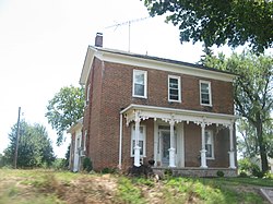
The Chenoweth-Coulter Farmhouse, a historic site in the township
|
|
 Location in Huntington County |
|
| Coordinates: 40°41′49″N 85°36′10″W / 40.69694°N 85.60278°WCoordinates: 40°41′49″N 85°36′10″W / 40.69694°N 85.60278°W | |
| Country | United States |
| State | Indiana |
| County | Huntington |
| Government | |
| • Type | Indiana township |
| Area | |
| • Total | 24.41 sq mi (63.2 km2) |
| • Land | 24.36 sq mi (63.1 km2) |
| • Water | 0.05 sq mi (0.1 km2) 0.20% |
| Elevation | 853 ft (260 m) |
| Population (2010) | |
| • Total | 540 |
| • Density | 22.2/sq mi (8.6/km2) |
| GNIS feature ID | 0454032 |
Wayne Township is one of twelve townships in Huntington County, Indiana, United States. As of the 2010 census, its population was 540 and it contained 237 housing units.
Wayne Township was organized in 1844. Some of the early settlers being natives of Wayne County, Indiana caused the name to be selected.
The Chenoweth-Coulter Farm was listed on the National Register of Historic Places in 2009.
According to the 2010 census, the township has a total area of 24.41 square miles (63.2 km2), of which 24.36 square miles (63.1 km2) (or 99.80%) is land and 0.05 square miles (0.13 km2) (or 0.20%) is water. The stream of Prairie Creek runs through this township.
The township contains one cemetery, Gardens of Memory.
...
Wikipedia
