West Goshen Township, Pennsylvania
| West Goshen Township | ||
|---|---|---|
| Township | ||

|
||
|
||
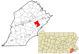
 Location in Chester County and the state of Pennsylvania. |
||
 Location of Pennsylvania in the United States |
||
| Coordinates: 39°58′21″N 75°34′58″W / 39.97250°N 75.58278°WCoordinates: 39°58′21″N 75°34′58″W / 39.97250°N 75.58278°W | ||
| Country | United States | |
| State | Pennsylvania | |
| County | Chester | |
| Founded | 1681 | |
| Area | ||
| • Total | 12.0 sq mi (31 km2) | |
| • Land | 11.9 sq mi (31 km2) | |
| • Water | 0.1 sq mi (0.3 km2) | |
| Elevation | 469 ft (143 m) | |
| Population (2010) | ||
| • Total | 21,866 | |
| • Estimate (2016) | 23,037 | |
| • Density | 1,719.6/sq mi (663.9/km2) | |
| Time zone | EST (UTC-5) | |
| • Summer (DST) | EDT (UTC-4) | |
| FIPS code | 42-029-83080 | |
| Website | www |
|
West Goshen Township is a township in Chester County, Pennsylvania, United States. The population was 21,866 at the 2010 census. In 2013, Money Magazine voted West Goshen as the 10th best place to live in America. West goshen has also been ranked in the top 15 places to live in america from 2014-2017 and is also at the top of best neighborhoods to raise a family in PA every year.
The headquarters for QVC is in West Goshen Township, though its address is in West Chester. West Goshen Township is also where the headquarters for A. Duie Pyle Trucking, Teva Pharmaceuticals, and Lasko Industries are located. There are more than 465 businesses which call West Goshen Township home.
The lands of Goshen were purchased in 1681 from William Penn as part of the Welsh tract of Westtown. By 1704, Goshen and Westtown had become separate townships. In 1788, the formation of the Borough of West Chester reduced the size of Goshen. Finally, in 1817, the Township divided into East and West Goshen Townships. At the time of the 1820 census, West Goshen's population numbered 757.
West Goshen was primarily a farming community in its early history. Before long, many different businesses began to appear, including several women-owned enterprises. Trades such as cabinet-making, tailoring, weaving, clock-making, and wool-making characterized the area. The completion of railroads in the 1830s and 1850s facilitated the delivery of goods and services to the Township, and marked the migration of many Philadelphians seeking country residences.
By 1930, West Goshen's population had risen to 1,958. The farming community had grown into a suburban neighborhood. In 1950, the population was 3,500. The Township experienced its most explosive growth during the 1960s and 1970s, and today can boast over 20,000 residents and a balanced mix of residential, business, office, retail, and industrial uses.*
According to the United States Census Bureau, the township has a total area of 12.0 square miles (31.2 km²), of which, 11.9 square miles (30.9 km²) of it is land and 0.1 square miles (0.3 km²) of it (0.91%) is water.
As of the 2010 census, the township was 88.8% White, 3.7% Black or African American, 0.2% Native American, 4.7% Asian, and 1.4% were two or more races. 3.7% of the population were of Hispanic or Latino ancestry.
As of the census of 2000, there were 20,495 people, 7,554 households, and 5,484 families residing in the township. The population density was 1,719.6 people per square mile (663.9/km²). There were 7,703 housing units at an average density of 646.3/sq mi (249.5/km²). The racial makeup of the township was 90.51% White, 4.25% African American, 0.04% Native American, 3.78% Asian, 0.01% Pacific Islander, 0.65% from other races, and 0.76% from two or more races. Hispanic or Latino of any race were 2.00% of the population.
...
Wikipedia

