West Keal
| Keal Cotes | |
|---|---|
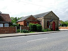
 Former Wesleyan Chapel, Keal Cotes in 2007 |
|
| Keal Cotes shown within Lincolnshire | |
| Population | 327 (2011) |
| OS grid reference | TF365611 |
| • London | 110 mi (180 km) S |
| Civil parish |
|
| District | |
| Shire county | |
| Region | |
| Country | England |
| Sovereign state | United Kingdom |
| Post town | SPILSBY |
| Postcode district | PE23 |
| Dialling code | 01790 |
| Police | Lincolnshire |
| Fire | Lincolnshire |
| Ambulance | East Midlands |
| EU Parliament | East Midlands |
| UK Parliament | |
Keal Cotes, forming part of West Keal parish, is a small linear village in East Lindsey district of Lincolnshire, England. It is situated on the A16 road, 1 mile (1.6 km) south from West Keal and 1 mile north from Stickford. The nearest market town is Spilsby, about 6 miles (10 km) to the north. Keal Cotes market day is on Mondays.
The village is at the southern edge of the Lincolnshire Wolds north of the Fenlands, and approximately 25 miles (40 km) east from the city and county town of Lincoln, 11 miles (18 km) north-east from the market town of Boston, and 12 miles (19 km) west from the holiday resort of Skegness.
The remains of a substantial Roman villa or high status Romano-British farmhouse, the only one found in Lincolnshire, are located in a large field at the south end of the village.
The name of the village is occasionally spelt on some maps as "Keal Coates".
The area has been occupied by man since pre-historic times. Evidence for this can be found at nearby West Keal where an Iron Age hill fort and defensive terraced earthworks stood at the tip of the Wolds promontory overlooking the present village. The early fortified stronghold had a commanding view of the Wash and almost as far as modern day Spalding across the flat marsh and boglands below.
The Keal Cotes area was visited and occupied by the Romans during the 1st century until the 4th century AD. An archeological dig and field walk in the village, during the 1960s, over a large field to the south of the village (in the corner where the A16 meets the Hagnaby Lane), discovered many tessellated mosaic floor tiles and roof tiles indicating that a substantial Roman villa or high status Romano-British farmhouse had once stood on the site. Several centuries of agricultural activity had plowed out any possibility of further excavations although the cropmark outlines of an extensive dwelling can be clearly seen on several aerial photographs.
...
Wikipedia

