West Midlands conurbation
| West Midlands | |
|---|---|
| Conurbation | |
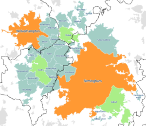
 Map of the West Midlands conurbation in 2011, with Travel to Work Areas overlaid. The Birmingham and Wolverhampton sub-divisions are highlighted in orange, the Dudley, Walsall and Solihull sub-divisions are highlighted in green. |
|
| Sovereign state | United Kingdom |
| Constituent country | England |
| Largest settlements |
(Pop. 100,000+)
|
| Population (2011 census) | |
| • Total | 2,440,986 |
| • Rank | 3rd |
| Time zone | GMT (UTC+0) |
| • Summer (DST) | BST (UTC+1) |
| Postcode | B, DY, WS, WV |
| Area code(s) | 0121, 01543, 01562, 01384, 01902, 01922 |
The West Midlands conurbation is the large conurbation that includes the cities of Birmingham and Wolverhampton and the large towns of Sutton Coldfield, Dudley, Walsall, West Bromwich, Solihull, Stourbridge and Halesowen in the English West Midlands.
Not to be confused with the region or metropolitan county of the same name, the conurbation does not include parts of the metropolitan county such as Coventry, but does include parts of the surrounding counties of Staffordshire (e.g. Little Aston, Perton and Essington) and Worcestershire (such as Hagley and Hollywood).
According to the 2011 Census the area had a population of 2,440,986, making it the third most populated in the United Kingdom behind the Greater London and Greater Manchester Built Up Areas.
The conurbation has several lesser used unofficial names, such as the Birmingham conurbation, the Birmingham-Wolverhampton conurbation and the Birmingham/Black Country conurbation.
...
Wikipedia
