Western Rocks (Tasmania)

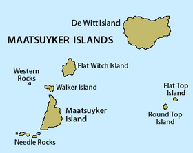
Detailed map of the Maatsuyker Islands Group, showing Western Rocks mid-left.
|
|
| Geography | |
|---|---|
| Location | South West Tasmania |
| Coordinates | 43°37′48″S 146°15′00″E / 43.63000°S 146.25000°ECoordinates: 43°37′48″S 146°15′00″E / 43.63000°S 146.25000°E |
| Archipelago | Maatsuyker Islands Group |
| Adjacent bodies of water | Southern Ocean |
| Area | 0.29 ha (0.72 acres) |
| Highest elevation | 165 m (541 ft) |
| Administration | |
|
Australia
|
|
| State | Tasmania |
| Region | South West |
| Demographics | |
| Population | Unpopulated |
The Western Rocks, also known as Black Rocks, are a pair of islets located close to the south-western coast of Tasmania, Australia. The steep, wave-washed 0.29-hectare (0.0011 sq mi) islets are part of the Maatsuyker Islands Group, and comprises part of the Southwest National Park and the Tasmanian Wilderness World Heritage Site.
The only recorded breeding seabird species is the fairy prion with up to 20 pairs in a small patch of succulent vegetation.
...
Wikipedia

