Wetaskiwin (electoral district)
|
|
|
|---|---|

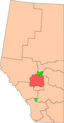
Wetaskiwin in relation to the other Alberta federal electoral districts (2003 boundaries)
|
|
| Defunct federal electoral district | |
| Legislature | House of Commons |
| District created | 1924 |
| District abolished | 2013 |
| First contested | 1925 |
| Last contested | 2011 |
| District webpage | profile, map |
| Demographics | |
| Population (2011) | 113,780 |
| Electors (2011) | 79,862 |
| Area (km²) | 14,996.45 |
| Census divisions | Division No. 8, Division No. 9, Division No. 11 |
| Census subdivisions | Leduc County, Clearwater County, Wetaskiwin, Lacombe, County of Wetaskiwin No. 10, Lacombe County, Ponoka County, Brazeau County, Rocky Mountain House, Ponoka |
Wetaskiwin was a federal electoral district in Alberta, Canada, that was represented in the House of Commons of Canada from 1925 to 2015.
This riding is located south of Edmonton and is legally described as commencing at the intersection of the westerly limit of the Town of Devon with the right bank of the North Saskatchewan River; thence generally southeasterly along the westerly limit of said town to the southwesterly corner of said town (at Highway 60); thence southerly along said highway to Township Road 494; thence easterly along said road to the westerly limit of the City of Leduc; thence easterly, southerly, easterly, northerly and easterly along the southerly limit of said city to Highway No. 623; thence easterly along said highway to the easterly limit of Leduc County; thence generally southwesterly along said limit to the northerly limit of the County of Wetaskiwin No. 10; thence easterly and generally southerly along the northerly and easterly limits of said county to the easterly limit of Ponoka County; thence generally southerly along said limit to the northerly limit of Lacombe County; thence generally southeasterly, generally southerly and generally westerly along the northerly, easterly and southerly limits of said county to the east boundary of R 4 W 5; thence south along the east boundary of R 4 W 5 to the south boundary of Tp 38; thence west along the south boundary of Tp 38 to the west boundary of R 8 W 5; thence north along the west boundary of R 8 W 5 to the north boundary of Tp 41; thence east along the north boundary of Tp 41 to the right bank of the North Saskatchewan River; thence generally northerly and generally easterly along said bank to the point of commencement.
This federal electoral riding represents the County of Wetaskiwin No. 10, Ponoka County, Lacombe County, Leduc County and part of Clearwater County.
...
Wikipedia
